
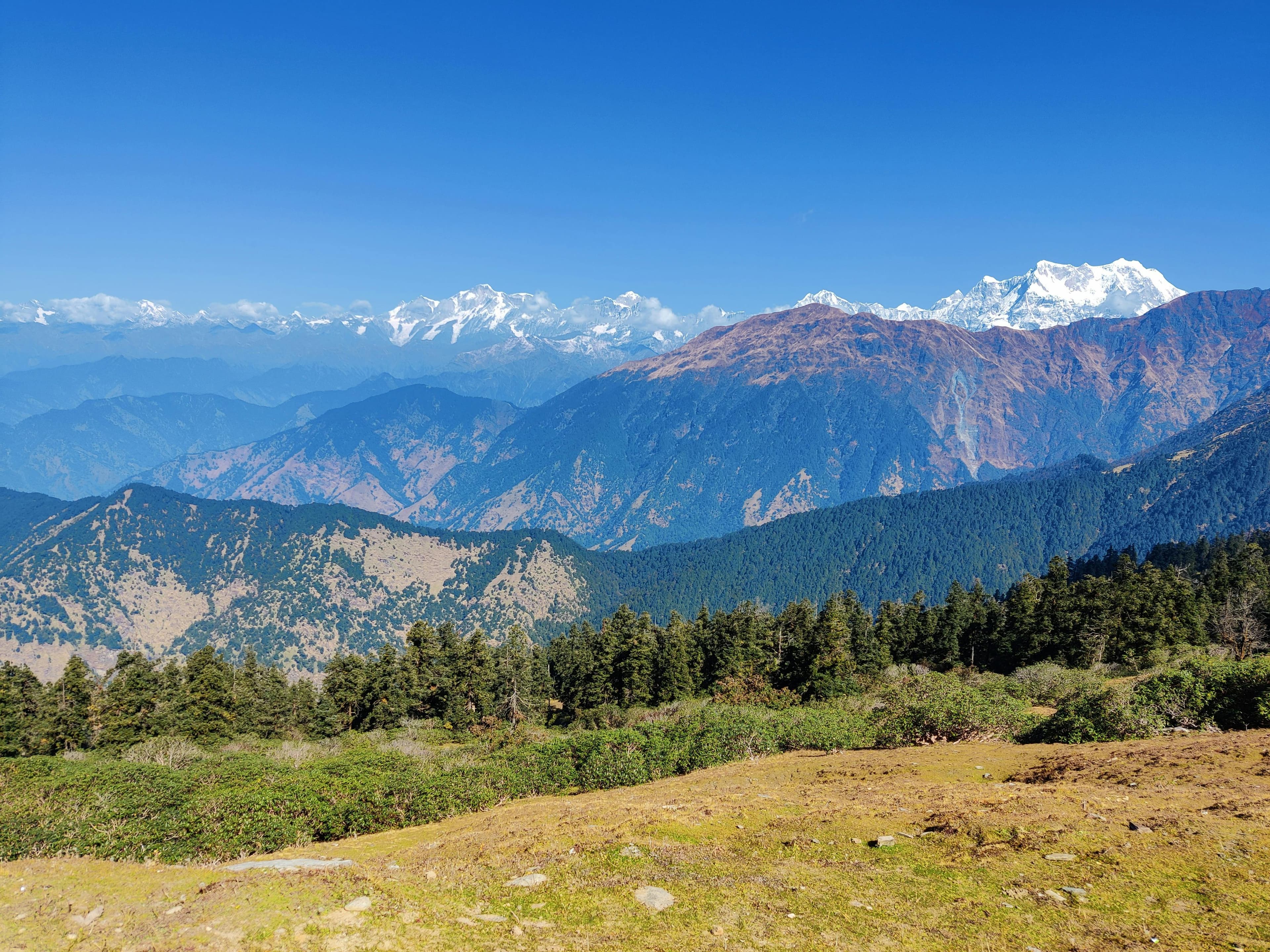
Khopra Danda (Khopra Ridge) Trek: overview
- Duration
- 7–11 days (typically 9)
- Difficulty
- Challenging
- Max altitude
- 4,660 m · Khayar Lake (optional day hike)
- Start / finish
- Nayapul / Ulleri (jeep from Pokhara) → Ghandruk (jeep to Pokhara)
- Best months
- Mar, Apr, Oct, Nov
- Sleep in
- Standard teahouses at Ulleri, Ghorepani, Tadapani and Ghandruk. Between Swanta and Dobato you stay in simpler community-run lodges at Chistibang and Khopra, set up by Mahabir Pun's Himanchal Education Foundation, whose profits support local schools. Khopra has a mix of rooms and dorms, and there is no lodge at Khayar Lake.
- Guide
- Licensed guide required
- Permits
- Annapurna Conservation Area Permit (ACAP), TIMS card
Khopra Danda is a grassy ridge at about 3,660 m, one valley west of the Annapurna Sanctuary and high above the Kali Gandaki. From the lodge terrace you look across the world's deepest gorge to Dhaulagiri (8,167 m), with Annapurna South (7,219 m), Barah Shikhar/Fang (7,647 m), Nilgiri and Tukuche Peak close by. It sees a fraction of Poon Hill's traffic and still feels remote, even though it is only three days' walk from the road.
The standard 9-day loop from Pokhara climbs the Poon Hill staircase to Ghorepani, drops into Swanta, a Magar village with a cheese factory, and climbs through forest to the community lodges at Chistibang and Khopra. A full day from Khopra takes you to Khayar (Khayer) Lake, a sacred glacial lake below Annapurna South at about 4,660 m (figures quoted range from 4,500 to 4,665 m). The return follows the high trail past Muldai viewpoint and Dobato to Tadapani and Ghandruk.
The Khayar day is long and high, making this a Challenging trek even though it is only 3,660 m on the ridge. The community lodges are basic, but well run and warm with a stove in the dining room. Choose it if you've done Poon Hill, or want the same mountains without the crowds.
Highlights
- Face-on sunrise over Dhaulagiri (8,167 m) and the Kali Gandaki gorge from the Khopra ridge
- Khayar Lake (about 4,660 m), a sacred glacial lake beneath Annapurna South and Barah Shikhar
- Sunrise from Poon Hill (3,210 m) and Muldai viewpoint (about 3,640 m) on the same trek
- Community lodges whose income funds local schools and health posts
- Swanta's cheese factory, and yak herders at their summer pastures
- Rhododendron forest between Ghorepani, Dobato and Tadapani
- Far fewer trekkers than Poon Hill or ABC once you leave Ghorepani
Day-by-day itinerary & route map
The standard 9-day itinerary from Pokhara. Tap any day, a marker on the map or a point on the altitude profile to follow the route. Walking times are for an average trekker at a steady pace, without long stops.
Route line and stops are approximate and drawn for planning — not for navigation. Terrain tiles © OpenTopoMap / OpenStreetMap contributors.
Show altitudes as a table
| Day | Route | Sleep | High point |
|---|---|---|---|
| 1 | Pokhara → Nayapul → Hile/Tikhedhunga (jeep) → Ulleri | 2,020 m | — |
| 2 | Ulleri → Banthanti → Nangethanti → Ghorepani | 2,860 m | — |
| 3 | Poon Hill sunrise → Ghorepani → Swanta | 2,270 m | 3,210 m (Poon Hill) |
| 4 | Swanta → Chistibang | 2,990 m | — |
| 5 | Chistibang → Khopra Danda | 3,660 m | — |
| 6 | Khopra → Khayar Lake → Khopra (day hike) | 3,660 m | 4,660 m (Khayar Lake) |
| 7 | Khopra → Chistibang → Bayeli → Dobato | 3,420 m | — |
| 8 | Muldai sunrise → Dobato → Tadapani → Ghandruk | 1,940 m | 3,640 m (Muldai viewpoint) |
| 9 | Ghandruk → Pokhara (jeep) | 820 m | — |
Day 1: Pokhara → Nayapul → Hile/Tikhedhunga (jeep) → Ulleri
- Sleep altitude
- ▲ 2,020 m
- Time
- ⏱ 2.5–3 h drive + 1.5–2 h walk
- Distance
- ≈ 3 km
Drive to Nayapul and continue by jeep up the Bhurungdi Khola road to Hile or Tikhedhunga (about 1,540 m). From here the famous staircase climbs about 500 m to the Magar village of Ulleri, where Annapurna South and Hiunchuli appear at the top of the valley.
Overnight: Teahouse, Ulleri
Local tip: Jeeps now drive on to Ulleri and beyond, but walking the stairs is good training for the Khayar day.
Day 2: Ulleri → Banthanti → Nangethanti → Ghorepani
- Sleep altitude
- ▲ 2,860 m
- Time
- ⏱ 4–5 h walk
- Distance
- ≈ 8 km
A steady climb through oak and rhododendron forest past Banthanti and Nangethanti to Ghorepani, a large lodge village on the pass. This is the busy Poon Hill trail, so expect company and good lodges. Walk up to the Poon Hill tower for sunset if the afternoon is clear.
Overnight: Teahouse, Ghorepani
Day 3: Poon Hill sunrise → Ghorepani → Swanta
- Sleep altitude
- ▲ 2,270 m
- High point
- Max 3,210 m · Poon Hill
- Time
- ⏱ 1.5 h Poon Hill + 3–4 h walk
- Distance
- ≈ 9 km
Climb 45 minutes to Poon Hill (3,210 m) before dawn for the classic panorama from Dhaulagiri to Machhapuchhre. After breakfast, leave the crowds and descend north through forest and farmland to Swanta, a Magar village with terraced fields and a small cheese factory.
Overnight: Community lodge / teahouse, Swanta
Local tip: Stock up on snacks and cash-bought extras at Ghorepani; the shops beyond Swanta are few and basic.
Day 4: Swanta → Chistibang
- Sleep altitude
- ▲ 2,990 m
- Time
- ⏱ 4–5 h walk
- Distance
- ≈ 6 km
Cross the stream below Swanta and climb steadily through rhododendron and bamboo forest with herders' clearings. Chistibang (also called Dhan Kharka) is a community lodge in a forest clearing, and stopping here keeps the ascent to Khopra manageable.
Overnight: Community lodge, Chistibang
Local tip: Many itineraries go from Swanta straight to Khopra (6–7 h, +1,400 m). Splitting it at Chistibang is gentler on your head before the Khayar day.
Day 5: Chistibang → Khopra Danda
- Sleep altitude
- ▲ 3,660 m
- Time
- ⏱ 2.5–3 h walk
- Distance
- ≈ 3 km
- Type
- Acclimatisation day
A short, steep climb out of the forest onto open yak pasture brings you to the Khopra lodge on the ridge crest. The view opens across the Kali Gandaki to Dhaulagiri, Tukuche Peak and Nilgiri. The afternoon is free to acclimatise; walk 100–200 m up the ridge above the lodge and come back down to sleep.
Overnight: Community lodge, Khopra Danda
Day 6: Khopra → Khayar Lake → Khopra (day hike)
- Sleep altitude
- ▲ 3,660 m
- High point
- Max 4,660 m · Khayar Lake
- Time
- ⏱ 7–9 h walk (return)
- Distance
- ≈ 16 km
Leave at first light and follow the high trail north-east across pasture and scree, climbing about 1,000 m to Khayar Lake beneath Annapurna South and Barah Shikhar. The lake is sacred to Hindus, who make pilgrimages here at the full moon of August (Janai Purnima). The last stretch is steep and often snow-covered from December to April, so allow 4–5 h up and 3–4 h down.
Overnight: Community lodge, Khopra Danda
Local tip: Turn back by 12 noon wherever you are. Cloud and afternoon wind arrive fast, and there is no shelter at the lake.
Day 7: Khopra → Chistibang → Bayeli → Dobato
- Sleep altitude
- ▲ 3,420 m
- Time
- ⏱ 5–6 h walk
- Distance
- ≈ 9 km
Descend to Chistibang, then take the high forest trail south-east via the herders' settlement at Bayeli to Dobato, a small lodge settlement in a clearing. The trail has ups and downs, and patches of snow linger in the forest in early spring.
Overnight: Teahouse, Dobato
Day 8: Muldai sunrise → Dobato → Tadapani → Ghandruk
- Sleep altitude
- ▲ 1,940 m
- High point
- Max 3,640 m · Muldai viewpoint
- Time
- ⏱ 1 h Muldai + 6–7 h walk
- Distance
- ≈ 14 km
Climb 30–45 minutes above Dobato to Muldai viewpoint for sunrise, which many trekkers rate above Poon Hill, then descend through dense rhododendron forest to Tadapani (2,630 m). The trail then drops steeply for 700 m to Ghandruk, a big Gurung village with stone-slab roofs and a view of Machhapuchhre.
Overnight: Teahouse, Ghandruk
Local tip: Visit the Gurung museum and the ACAP office in Ghandruk if you arrive with time to spare.
Day 9: Ghandruk → Pokhara (jeep)
- Sleep altitude
- ▲ 820 m
- Time
- ⏱ 3 h drive
Jeeps and local buses leave Ghandruk down the Modi Khola road via Kimche to Nayapul and Pokhara. You'll be back at the lake by lunchtime.
Overnight: Hotel, Pokhara
Best time to trek
- Jan: not ideal
- Feb: possible
- Mar: best
- Apr: best
- May: possible
- Jun: not ideal
- Jul: not ideal
- Aug: not ideal
- Sep: possible
- Oct: best
- Nov: best
- Dec: possible
Not sure which season suits you? Our month-by-month guide to trekking in Nepal covers weather, crowds and festivals.
Permits, fees & the guide rule
| Permit | Cost (foreigners) | Notes |
|---|---|---|
| Annapurna Conservation Area Permit (ACAP) | NPR 3,000 (≈ USD 22) | SAARC nationals NPR 1,000. Issued in Pokhara (Nepal Tourism Board office, Damside) or Kathmandu (Bhrikutimandap); carry it with your passport as it is checked several times. |
| TIMS card | NPR 2,000 (≈ USD 15) | Issued through a registered trekking agency, together with your licensed guide. |
Licensed guide required for foreign trekkers
Since 1 April 2023 the Nepal Tourism Board requires foreign trekkers to walk with a licensed guide arranged through a registered agency in conservation areas, including the Annapurna Conservation Area. Enforcement at Annapurna checkpoints has been inconsistent, but plan on a guide (or at minimum a licensed porter-guide) rather than counting on walking alone, and check the current rules before you travel.
Fees as of September 2026. Nepal changes permit rules and prices from time to time — confirm before you travel. Full details in our Nepal trekking permits guide.
Getting there
From Pokhara
Take a private jeep or taxi from Lakeside to Nayapul (1.5–2 h), then a local jeep up to Hile, Tikhedhunga or Ulleri, or book one jeep for the whole way. To walk the loop in reverse, drive to Ghandruk (about 3 h) and start via Tadapani and Dobato.
From Kathmandu
Take a tourist bus (USD 10–25, 6–8 h) or fly (USD 100–130, 25 min) to Pokhara, and spend a night there to collect permits and meet your guide.
Getting back
From Ghandruk, jeeps and local buses run to Pokhara in about 3 h. If you exit west to Tatopani instead, local buses and jeeps run along the Kali Gandaki road via Beni to Pokhara (5–7 h).
How much does the Khopra Danda trek cost?
Move the sliders to estimate your own trip. Typical teahouse spend on this route is USD 28–45 per person per day for a room and three meals; a licensed guide costs USD 25–35 a day and a porter USD 18–25.
Estimated cost per person
USD 438
+ about USD 16 in tips for your staff
- Teahouse room & 3 meals × 9 daysUSD 252
- PermitsUSD 36
- Transport to & from trailheadUSD 15
- Licensed guide (shared by 2)USD 135
Do-it-yourself estimate for the Khopra Danda (Khopra Ridge) Trek, from typical 2026 teahouse prices. Excludes flights to Nepal, visa, insurance, gear, drinks, hot showers and charging fees.
- Community lodges at Chistibang and Khopra charge set prices similar to Ghorepani; meals are simple, but hot drinks are plentiful.
- A jeep from Pokhara to Ulleri costs roughly USD 60–90 per vehicle, and from Ghandruk to Pokhara USD 60–90.
- Khopra lodge sometimes charges a little extra for charging and hot showers (solar only).
- There is no food or water at Khayar Lake, so buy a packed lunch the night before.
Important things to know
Altitude & acclimatisation
Sleeping altitudes stay below 3,700 m, but the Khayar Lake day adds about 1,000 m of ascent and takes you to about 4,660 m. Spending an acclimatisation afternoon at Khopra, and taking the Chistibang stop before it, makes a big difference. If you have a headache at Khopra, skip the lake: the views from the ridge are the main event anyway.
Khayar Lake day
This is a big mountain day on an intermittent trail with no lodges or shelter. From December to April the upper section can be snow-covered and the route hard to follow. It should only be done with a guide who knows the way, in clear weather, with an early start and a firm turnaround time.
Trail conditions & roads
The first two days share the busy Poon Hill trail and its stone staircases. Beyond Swanta the trails are narrower forest and pasture paths, muddy after rain and occasionally confusing where herders' tracks branch off. Jeep roads now reach Ulleri and Ghandruk, which shortens the start and finish.
Community lodges
The lodges at Chistibang and Khopra were built by local communities with the Himanchal Education Foundation, and their profits pay for teachers and health posts. Rooms are simple, with few beds, so in October and April a guide should phone ahead. Expect dal bhat, noodles, porridge and local cheese.
Water & food
Lodges sell boiled water, and Ghorepani and Ghandruk have ACAP refill stations. Between Swanta and Khopra streams are available but should be treated. Carry snacks from Ghorepani for the Khayar day.
Charging, Wi-Fi & mobile network
Ghorepani, Tadapani and Ghandruk have 4G on NTC and Ncell and Wi-Fi in most lodges. Khopra has a signal on the ridge crest on some days, and a Wi-Fi link was set up by the Nepal Wireless project, but don't rely on it. Solar charging at the community lodges is limited on cloudy days.
Money & ATMs
There are no ATMs on the route. Take enough cash from Pokhara for the whole trek, and small notes for the community lodges, which may lack change.
Weather & hazards
October–November and March–April are best. Winter brings snow to Khopra and Dobato, closing the Khayar trail, while the monsoon (June–September) brings leeches and landslides below Swanta. On the ridge, afternoon wind is cold and strong at any time of year.
Rescue & insurance
Helicopters can land on the Khopra ridge in clear weather, and evacuation costs USD 3,000–6,000+. Your insurance must cover trekking to 4,700 m and helicopter rescue.
Tips for solo trekkers
- Once you leave Ghorepani you may walk for hours without seeing another trekker, so a guide is legally required and also sensible.
- Never attempt Khayar Lake alone. The trail fades on the upper slopes, and there is nobody to raise the alarm.
- Poon Hill, Ghorepani and Tadapani are good places to meet other trekkers. At Khopra you'll usually share the dining room with one or two small groups.
- Ask your guide to phone ahead to Chistibang and Khopra; with a small number of beds, arriving unannounced as a solo trekker can mean a dorm bunk.
- Women travelling alone generally find the community lodges safe and friendly, as they are run by local families and village committees.
- Avoid December–February if you are set on reaching Khayar Lake, since snow often blocks the upper trail.
- Walk the loop in the direction described (Poon Hill first) if you want to meet other trekkers early on and have quieter days later.
More in our complete guide to solo trekking in Nepal.
What to pack for this trek
- Sleeping bag rated to about −10 °C; the community lodges are cold at night
- Packed lunch, snacks and 2 litres of water for the Khayar Lake day
- Microspikes and gaiters from December to April for snow on the Khayar trail
- Down jacket and warm hat for sunrise on Poon Hill, Khopra and Muldai
- Trekking poles for the Ulleri staircase and the 700 m descent from Tadapani
- Power bank; solar charging at Khopra is limited
- Small notes (NPR 100–500) for the community lodges
- Leech socks for the forest in the monsoon and early autumn
The basics are the same for every Nepal trek — see our interactive packing checklist.
Route options & variations
Khopra without Khayar Lake (7–8 days)
Skip the lake day and spend only one night at Khopra. It is the same loop but with a maximum altitude of 3,660 m, which makes it a Moderate trek suited to anyone who has done Poon Hill.
Reverse loop from Ghandruk
Drive to Ghandruk and go up via Tadapani, Dobato and Muldai to Chistibang and Khopra, then exit via Swanta, Ghorepani and Poon Hill. Acclimatisation is similar, and you end on the easier Poon Hill stairs down to the road.
Exit to Tatopani and the Kali Gandaki
From Khopra, descend west through Paudwar and farming villages to the Kali Gandaki road at Tatopani (about 1,190 m) over one long day or two shorter ones. Soak in Tatopani's hot springs, then take a bus or jeep via Beni to Pokhara. This exit is steep and knee-heavy but very quiet.
Mohare Danda + Khopra (10–12 days)
Start from Galeshwor near Beni on the Mohare Danda community trail via Banskharka and Nangi, cross the ridge to Poon Hill and Ghorepani, then continue to Swanta and Khopra. This links the two community-lodge treks into one long, quiet route.
Our recommendation
Plan the Khopra Danda (Khopra Ridge) Trek with a Pokhara team
We are a local operator based in Pokhara — the gateway to most of the treks in this guide. Booking with us means a government-licensed guide, permits and TIMS arranged before you arrive, transport from your Pokhara hotel to the trailhead, and a team on the phone if plans change on the trail. Foreign trekkers must trek this route with a licensed guide anyway, so it pays to choose one you trust.
- Licensed, English-speaking local guides
- Permits & TIMS handled for you
- Solo travellers welcome
- Itineraries adjusted to your pace and dates
Khopra Danda FAQ
How difficult is the Khopra Danda trek?
Without Khayar Lake it is moderate, with 4–6 h days and a maximum sleeping altitude of about 3,660 m. The optional Khayar Lake day adds about 1,000 m of ascent to about 4,660 m and 7–9 h of walking, which makes the full trek challenging.
How many days is the Khopra Danda trek?
Nine days from Pokhara back to Pokhara is the standard loop, including a night at Chistibang and a day for Khayar Lake. You can do it in 7 days if you skip the lake and walk from Swanta straight to Khopra.
Can I do the Khopra Danda trek without a guide?
Officially no, as a licensed guide is required in the Annapurna Conservation Area. Even without the rule, this is a trek where a guide matters because the trails beyond Swanta are quieter, and the Khayar Lake route is hard to follow.
How much does the Khopra Danda trek cost?
Budget USD 28–45 a day for lodges and food, USD 25–35 a day for a guide, plus ACAP (NPR 3,000), TIMS (NPR 2,000) and USD 15–60 for jeeps. A 9-day trek with a guide typically comes to USD 550–800 per person.
What is the best time for the Khopra Danda trek?
October and November give the clearest views of Dhaulagiri, and March and April bring rhododendrons. The Khayar Lake trail is usually snowbound from December to March.
What is Khayar Lake?
Khayar (Khayer) Lake is a glacial lake at about 4,660 m below Annapurna South and Barah Shikhar, a day's walk above Khopra. It is sacred to Hindus and Buddhists, and pilgrims visit at the August full moon (Janai Purnima). There are no facilities at the lake.
Is there Wi-Fi on the Khopra trek?
There is reliable Wi-Fi and 4G at Ghorepani, Tadapani and Ghandruk. At Swanta, Chistibang and Khopra, connections are intermittent and slow, and you should expect to be offline for 2–3 days.
Do I need a permit for Khopra Danda?
Yes. Foreigners need the ACAP (NPR 3,000; SAARC NPR 1,000) and a TIMS card (NPR 2,000). Permits are checked at Ghorepani and Ghandruk.
Is Khopra Danda better than Poon Hill?
It is a longer, quieter version. You still get Poon Hill's sunrise, plus a much closer view of Dhaulagiri from Khopra and an optional high lake. If you have 4–5 days, do Poon Hill; if you have 8–9, Khopra is the better trek.
Still have questions? Browse 80+ answers about trekking in Nepal.
Ask us about the Khopra Danda trek
Tell us your dates, group size and fitness — our Pokhara team replies by email with honest advice, even if you decide to trek with someone else.