
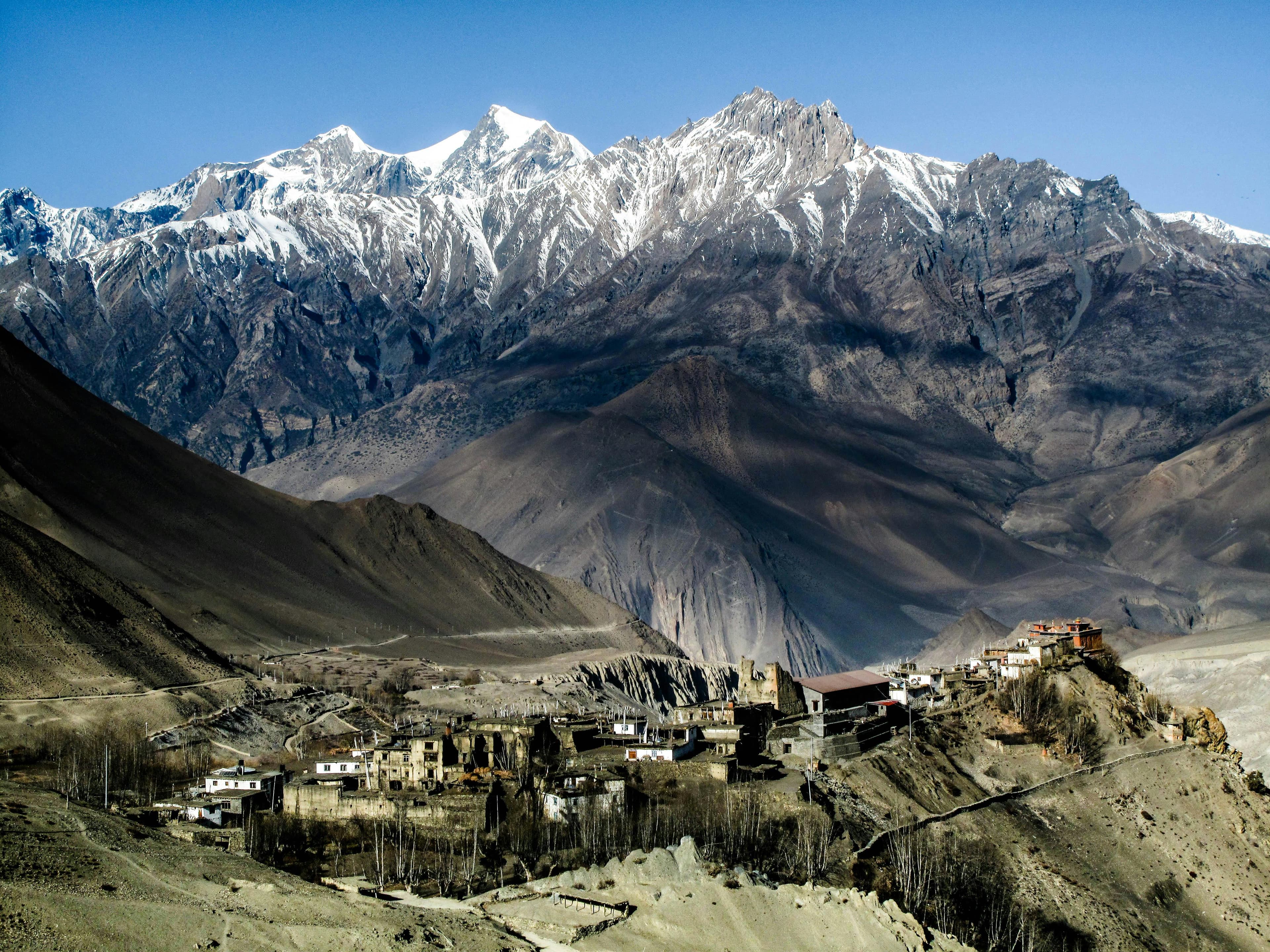
Jomsom Muktinath Trek: overview
- Duration
- 4–11 days (typically 5)
- Difficulty
- Moderate
- Max altitude
- 3,900 m · Lubra Pass (Muktinath Temple 3,800 m)
- Start / finish
- Jomsom (20-minute flight from Pokhara) → Jomsom (flight back to Pokhara)
- Best months
- Mar, Apr, May, Sep, Oct, Nov
- Sleep in
- Comfortable lodges throughout, many with attached bathrooms and hot showers, in Jomsom, Kagbeni, Muktinath (Ranipauwa) and Marpha.
- Guide
- Licensed guide required
- Permits
- Annapurna Conservation Area Permit (ACAP), TIMS card
The Jomsom Muktinath trek is a short high-desert trek in Lower Mustang, north of the main Himalayan range and in its rain shadow. You fly from Pokhara to Jomsom (2,720 m) through the Kali Gandaki gorge between Dhaulagiri and Annapurna I, then walk to the walled village of Kagbeni and up to Muktinath, a temple complex sacred to both Hindus and Buddhists.
The route is not remote: a road connects Jomsom, Kagbeni and Muktinath, and the lodges are some of the best in the Annapurna region. The trick is to walk the NATT footpaths through Jharkot and the side valley of Lubra instead of the road, and to walk in the mornings before the Kali Gandaki wind arrives around 11 am.
At 3,800 m, Muktinath is high enough to feel the altitude but far lower than the passes of the Annapurna Circuit, which makes this a good first Himalayan trek or an option for families and pilgrims. Mantra Mountain is based in Pokhara and runs this trek. The standard itinerary is five days from Pokhara, and you can extend it by walking down the Kali Gandaki to Tatopani and Poon Hill.
Highlights
- The 20-minute Pokhara–Jomsom flight between Dhaulagiri (8,167 m) and Annapurna I (8,091 m)
- Muktinath temple (3,800 m) with its 108 water spouts and the Jwala Mai shrine, where natural gas burns beside a spring
- Kagbeni, a medieval mud-brick village at the confluence of the Kali Gandaki and Jhong Khola, at the gateway to Upper Mustang
- The Bon-Buddhist village of Lubra in a quiet side valley, on the NATT trail from Muktinath to Jomsom
- Marpha's whitewashed lanes, apple orchards and apple brandy
- Views of Nilgiri, Dhaulagiri and Tukuche Peak across a dry, Tibet-like landscape
- Saligram ammonite fossils in the Kali Gandaki riverbed
Day-by-day itinerary & route map
The standard 5-day itinerary from Pokhara. Tap any day, a marker on the map or a point on the altitude profile to follow the route. Walking times are for an average trekker at a steady pace, without long stops.
Route line and stops are approximate and drawn for planning — not for navigation. Terrain tiles © OpenTopoMap / OpenStreetMap contributors.
Show altitudes as a table
| Day | Route | Sleep | High point |
|---|---|---|---|
| 1 | Pokhara → Jomsom (flight) → Kagbeni | 2,810 m | — |
| 2 | Kagbeni → Khingar → Jharkot → Muktinath | 3,760 m | 3,800 m (Muktinath Temple) |
| 3 | Muktinath → Lubra → Jomsom | 2,720 m | 3,900 m (Lubra Pass) |
| 4 | Jomsom → Thini → Dhumba Lake → Marpha | 2,670 m | — |
| 5 | Marpha → Jomsom → Pokhara (flight) | 822 m | — |
Day 1: Pokhara → Jomsom (flight) → Kagbeni
- Sleep altitude
- ▲ 2,810 m
- Time
- ⏱ 20 min flight + 3 h walk
- Distance
- ≈ 10 km
Take an early morning flight from Pokhara to Jomsom, which flies through the Kali Gandaki gorge with Dhaulagiri and Annapurna close on either side. After breakfast in Jomsom, walk north along the wide, stony riverbed via Eklai Bhatti to Kagbeni. Explore its narrow alleys, the red Kag Chode monastery and the viewpoint over the Upper Mustang checkpoint.
Overnight: Teahouse, Kagbeni
Local tip: Walk in the morning; from about 11 am a strong wind blows up the valley and the riverbed walk becomes a dusty slog.
Day 2: Kagbeni → Khingar → Jharkot → Muktinath
- Sleep altitude
- ▲ 3,760 m
- High point
- Max 3,800 m · Muktinath Temple
- Time
- ⏱ 4–5 h walk
- Distance
- ≈ 11 km
Climb about 950 m up the Jhong Khola valley on the NATT trail above the road, through the villages of Khingar and Jharkot, whose old fort and monastery overlook the valley. Ranipauwa, the lodge village below the temple, is a short walk from Muktinath. Visit the temple and the Jwala Mai shrine in the afternoon, or save it for dawn.
Overnight: Teahouse, Muktinath (Ranipauwa)
Local tip: Muktinath is at 3,760–3,800 m, high enough for mild altitude symptoms after a quick ascent from Jomsom. Drink well and do not rush.
Day 3: Muktinath → Lubra → Jomsom
- Sleep altitude
- ▲ 2,720 m
- High point
- Max 3,900 m · Lubra Pass
- Time
- ⏱ 5–6 h walk
- Distance
- ≈ 16 km
Visit the temple at dawn when pilgrims bathe under the 108 spouts, then take the quieter NATT trail south over a ridge (about 3,900 m) and down into the Panda Khola valley to Lubra, one of the few Bon villages in Nepal. Follow the valley down to the Kali Gandaki and walk south to Jomsom. There are no teahouses between Muktinath and Lubra, so carry water and snacks.
Overnight: Lodge, Jomsom
Local tip: In the monsoon or after heavy rain the Panda Khola can flood; ask locally and take the Kagbeni road route instead if needed.
Day 4: Jomsom → Thini → Dhumba Lake → Marpha
- Sleep altitude
- ▲ 2,670 m
- Time
- ⏱ 3–4 h walk
- Distance
- ≈ 9 km
Cross to the east bank of the Kali Gandaki to Thini, one of the oldest villages in the valley, and the small Dhumba Lake with views of Nilgiri. Continue on the east-bank trail and cross back to Marpha, a Thakali village of whitewashed stone houses, flat roofs stacked with firewood and apple orchards. Visit the gompa above the village and try apple pie or brandy.
Overnight: Teahouse, Marpha
Day 5: Marpha → Jomsom → Pokhara (flight)
- Sleep altitude
- ▲ 822 m
- Time
- ⏱ 20 min jeep (or 1.5 h walk) + 20 min flight
Take an early jeep (or walk the evening before) to Jomsom for the morning flight to Pokhara. Flights run only in the morning and are frequently delayed or cancelled by wind and cloud. By road, buses and jeeps from Jomsom to Pokhara via Beni take 8–10 h.
Overnight: Hotel, Pokhara
Local tip: Many trekkers spend day 4 night in Jomsom instead of Marpha to be near the airport; it is only 6 km, and Marpha makes an easy afternoon visit.
Best time to trek
- Jan: not ideal
- Feb: not ideal
- Mar: best
- Apr: best
- May: best
- Jun: possible
- Jul: possible
- Aug: possible
- Sep: best
- Oct: best
- Nov: best
- Dec: possible
Not sure which season suits you? Our month-by-month guide to trekking in Nepal covers weather, crowds and festivals.
Permits, fees & the guide rule
| Permit | Cost (foreigners) | Notes |
|---|---|---|
| Annapurna Conservation Area Permit (ACAP) | NPR 3,000 (≈ USD 22); SAARC nationals NPR 1,000 | Issued in Pokhara or Kathmandu (Nepal Tourism Board) or by your agency. Checked at several ACAP posts; keep it with your passport. |
| TIMS card | NPR 2,000 (≈ USD 15) | Issued through a registered trekking agency together with your licensed guide. |
Licensed guide required for foreign trekkers
Lower Mustang is in the Annapurna Conservation Area, so the licensed-guide rule introduced in April 2023 applies. Enforcement has been inconsistent, but plan on travelling with a guide (or a porter-guide) arranged through a registered agency, and check current rules before you go.
Fees as of September 2026. Nepal changes permit rules and prices from time to time — confirm before you travel. Full details in our Nepal trekking permits guide.
Getting there
From Pokhara
Tara Air and Summit Air fly Pokhara–Jomsom several times each morning (20 minutes, about USD 125–140 one way for foreigners). Checked baggage is usually limited to 10–15 kg. By road, buses and jeeps take 8–10 h via Beni and the Kali Gandaki road, which is rough and slow in the monsoon.
From Kathmandu
There are no direct flights from Kathmandu to Jomsom. Fly (25 minutes, USD 100–130) or take a tourist bus (6–8 h) to Pokhara, spend the night, and take the first flight to Jomsom the next morning.
Getting back
Fly Jomsom–Pokhara in the morning, or take a jeep or bus down the Kali Gandaki via Tatopani and Beni (8–10 h). Jeeps also run from Muktinath directly to Pokhara. Keep a buffer day before international flights.
How much does the Jomsom Muktinath trek cost?
Move the sliders to estimate your own trip. Typical teahouse spend on this route is USD 30–45 per person per day for a room and three meals; a licensed guide costs USD 25–35 a day and a porter USD 18–25.
Estimated cost per person
USD 291
+ about USD 9 in tips for your staff
- Teahouse room & 3 meals × 5 daysUSD 150
- PermitsUSD 36
- Transport to & from trailheadUSD 30
- Licensed guide (shared by 2)USD 75
Do-it-yourself estimate for the Jomsom Muktinath Trek, from typical 2026 teahouse prices. Excludes flights to Nepal, visa, insurance, gear, drinks, hot showers and charging fees.
- Transport range: about USD 30 by bus both ways, up to USD 250–280 flying Pokhara–Jomsom–Pokhara. A guide's return flight is usually added to the package cost.
- Lodges in Jomsom, Kagbeni and Muktinath are larger and more comfortable than in most mountain villages; rooms with attached bathrooms cost USD 10–25.
- Marpha apple brandy and dried apples are the local speciality; allow a little extra for them.
Important things to know
Altitude
You climb from 2,720 m to about 3,800 m in two days. Most people only feel mild breathlessness at Muktinath, but headaches and poor sleep are common. If symptoms worsen, descend to Kagbeni or Jomsom, which is easy because of the road.
Roads and NATT trails
A road runs from Jomsom to Kagbeni and Muktinath, and jeeps and motorbikes use it daily. Use the NATT trails via Khingar and Jharkot and via Lubra to keep off it. Taking a jeep from Muktinath to Jomsom is a common shortcut if you are short of time or weather turns.
Wind & weather
Lower Mustang is in the rain shadow of the Annapurnas and Dhaulagiri, so it gets far less rain than Pokhara and can be trekked in the monsoon (June–August), though flights are delayed more often. A strong, dusty wind blows up the Kali Gandaki from late morning every day. Winters are dry but cold, with snow possible at Muktinath.
Flights
Jomsom flights only operate in the morning, in visual conditions, and are cancelled regularly. Build in at least one spare day at the end. If flights are grounded for several days, a jeep to Pokhara via Beni takes 8–10 h.
Water & food
Lodges serve good Thakali dal bhat, momos and Western food; Marpha and Jomsom have bakeries. Refill bottles with filtered water from lodges or ACAP water stations instead of buying plastic. Carry water on the Muktinath–Lubra section, which has no teahouses.
Charging, Wi-Fi & mobile network
Jomsom, Kagbeni, Muktinath and Marpha all have NTC and Ncell coverage and Wi-Fi in most lodges. Electricity is reliable in these villages, so charging is usually free or cheap.
Money & ATMs
Jomsom has several bank ATMs and is the best place to withdraw cash. There are fewer or no reliable ATMs in Kagbeni, Muktinath and Marpha, so carry enough rupees for two or three days. Card payments are rare outside a few Jomsom hotels.
Temples & responsible trekking
Muktinath is an active pilgrimage site: remove shoes where asked, do not photograph people bathing without permission and dress modestly. Walk clockwise around Buddhist chortens and mani walls. Buy Saligram fossils only from shops, never collect them from monasteries.
Tips for solo trekkers
- This is one of the easiest treks in Nepal to do as a solo traveller: villages are close together, lodges are comfortable and the road means help is never far away.
- The ACAP licensed-guide rule applies; a porter-guide is the cheapest way to meet it on your own.
- Muktinath is busy with Indian and Nepali pilgrims, especially in spring and autumn, so you are rarely alone on the trail up from Kagbeni.
- The Lubra trail is quiet; walk it with your guide or another trekker and carry water.
- Solo women trekkers generally find Lower Mustang very safe; Jomsom and Marpha have lodges run by Thakali women who are used to foreign guests.
- Watch out for motorbikes and jeeps on shared road sections, particularly around Jharkot and Kagbeni.
- If you are going on to Upper Mustang, you cannot continue north of Kagbeni alone: that needs a restricted area permit, a guide and a second trekker.
More in our complete guide to solo trekking in Nepal.
What to pack for this trek
- Buff or dust mask and sunglasses for the Kali Gandaki afternoon wind
- Windproof jacket; the wind is cold even on sunny days
- High-factor sunscreen and lip balm for the dry high-desert air
- Moisturiser; skin and lips crack quickly in Mustang
- Warm layers and a sleeping bag rated to about −5 °C for Muktinath
- Light daypack and 2 litres of water for the Lubra day
- Modest clothing for visiting Muktinath temple
The basics are the same for every Nepal trek — see our interactive packing checklist.
Route options & variations
Walk out via the Kali Gandaki and Tatopani (8–9 days)
From Marpha, continue south through Tukuche, Kalopani and Ghasa to the hot springs at Tatopani (1,190 m), on NATT trails on the opposite bank from the road where possible. From Tatopani, take a jeep to Beni and Pokhara.
Jomsom Muktinath with Poon Hill (10–11 days)
From Tatopani climb 1,700 m to Ghorepani (2,860 m) for sunrise at Poon Hill, then walk out via Ghandruk or Ulleri to Nayapul. It turns the trek into a full cross-section of the Annapurna region from desert to rhododendron forest.
Short pilgrimage version (3–4 days)
Fly to Jomsom, take a jeep to Muktinath, visit the temple and return via Kagbeni to Jomsom, flying out on day 3 or 4. This is common for pilgrims and those short of time, but it gives you less time to adjust to the altitude.
Our recommendation
Book the Jomsom Muktinath Trek with Mantra Mountain
We are a local operator based in Pokhara — the gateway to most of the treks in this guide. Booking with us means a government-licensed guide, permits and TIMS arranged before you arrive, transport from your Pokhara hotel to the trailhead, and a team on the phone if plans change on the trail. Foreign trekkers must trek this route with a licensed guide anyway, so it pays to choose one you trust.
- Licensed, English-speaking local guides
- Permits & TIMS handled for you
- Solo travellers welcome
- Itineraries adjusted to your pace and dates
Jomsom Muktinath FAQ
How difficult is the Jomsom Muktinath trek?
It is a moderate trek with 3–6 hours of walking a day on good trails. The main challenges are the 950 m climb from Kagbeni to Muktinath, the altitude at 3,800 m and the afternoon wind. Anyone in reasonable health who walks regularly can do it.
How many days do you need for Jomsom Muktinath?
The standard trek takes five days from Pokhara back to Pokhara, flying both ways. Add one buffer day for flight delays. Walking out via Tatopani takes 8–9 days, or 10–11 days including Poon Hill.
Can I do the Jomsom Muktinath trek without a guide?
Lower Mustang is in the Annapurna Conservation Area, where the licensed-guide rule has applied to foreign trekkers since April 2023. Enforcement has varied, but plan to go with a guide or porter-guide booked through a registered agency. The route itself is easy to follow.
How much does the Jomsom Muktinath trek cost?
Lodging and meals cost about USD 30–45 per day. The Pokhara–Jomsom flight is about USD 125–140 each way, a guide USD 25–35 per day and permits NPR 5,000 in total. A 5-day trek with a guide and return flights typically costs USD 550–800 per person.
What is the best time for the Jomsom Muktinath trek?
March to May and September to November are best for clear views and reliable flights. Because Mustang is in a rain shadow, it can also be trekked during the monsoon, when Pokhara is wet, although flights are cancelled more often. December to February is cold but usually dry.
Do I need a permit for Muktinath?
Yes, foreign trekkers need the ACAP permit (NPR 3,000; SAARC nationals NPR 1,000) and a TIMS card (NPR 2,000). No restricted area permit is needed for Jomsom, Kagbeni or Muktinath, but one is required to go north of Kagbeni into Upper Mustang.
Is the Jomsom Muktinath trek good for beginners?
Yes, it is one of the best first treks in Nepal: short days, comfortable lodges, a road nearby for emergencies and a maximum altitude of 3,800 m. Just allow time to acclimatise at Muktinath and keep a spare day for flights.
Can I drive to Muktinath instead of trekking?
Yes. Jeeps and buses run from Pokhara to Jomsom and Muktinath via Beni (about 10–12 h to Muktinath), and jeeps run from Jomsom to Muktinath in about 1.5 h. Many pilgrims drive, but walking between Kagbeni, Jharkot and Muktinath on the NATT trails is far more rewarding.
Is there Wi-Fi on the Jomsom Muktinath trek?
Yes. Almost all lodges in Jomsom, Kagbeni, Muktinath and Marpha have Wi-Fi, and NTC and Ncell mobile data work in the main villages. This is one of the best-connected treks in Nepal.
Still have questions? Browse 80+ answers about trekking in Nepal.
Ask us about the Jomsom Muktinath trek
Tell us your dates, group size and fitness — our Pokhara team replies by email with honest advice, even if you decide to trek with someone else.