
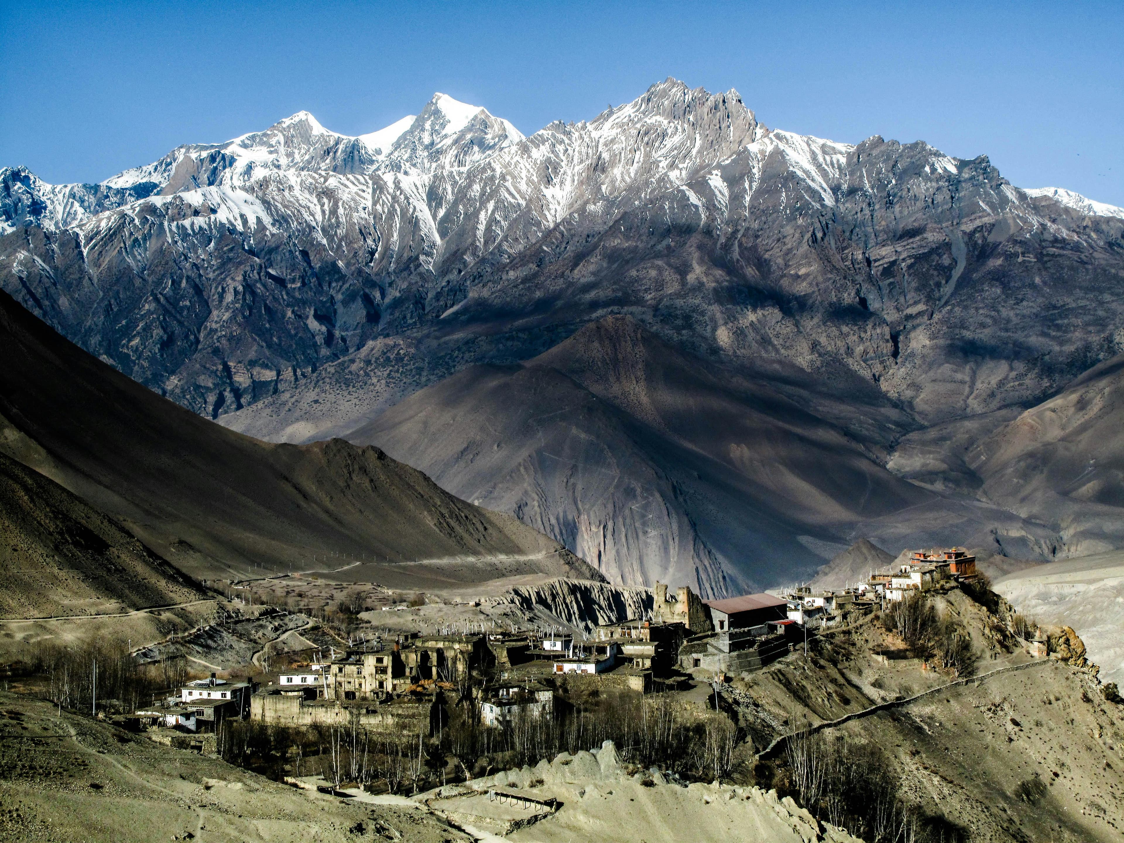
Upper Mustang Trek: overview
- Duration
- 9–16 days (typically 12)
- Difficulty
- Challenging
- Max altitude
- 4,230 m · Chogo La (on the Ghar Gompa return route)
- Start / finish
- Jomsom (flight from Pokhara), trek from Kagbeni → Jomsom (flight back to Pokhara)
- Best months
- Apr, May, Jun, Sep, Oct
- Sleep in
- Simple family-run teahouses in every overnight village, many with attached bathrooms in Lo Manthang, Tsarang and Ghami. Rooms are clean but cold, and hot showers are solar-heated.
- Guide
- Licensed guide required
- Permits
- Upper Mustang Restricted Area Permit, Annapurna Conservation Area Permit (ACAP), TIMS card
Upper Mustang is the northern half of Mustang district, a high, dry plateau that pushes into Tibet north of the Annapurna and Dhaulagiri ranges. Until 1992 it was closed to foreigners, and the former Kingdom of Lo still keeps its walled capital, Lo Manthang, its 15th-century monasteries and a Tibetan culture that is in many ways better preserved than in Tibet itself.
The trek starts with a flight from Pokhara to Jomsom and a walk to Kagbeni, where the restricted area begins. From there the route climbs through the eroded red and ochre cliffs of the upper Kali Gandaki, over a series of passes between 3,600 and 4,000 m, to the villages of Chele, Syangboche, Ghami and Tsarang and finally Lo Manthang (3,810 m). A day of exploration from Lo Manthang, then a return via Dhakmar and Ghar Gompa, completes the loop.
A road now runs to Lo Manthang and on to the Chinese border, and jeeps use it daily. Good itineraries use the foot trails on the opposite side of the valley wherever possible, and the return via Ghar Gompa avoids the road entirely. The USD 500 permit makes this an expensive trek, but it is also one of the few in Nepal that stays trekkable through the monsoon.
Highlights
- Lo Manthang (3,810 m), the walled capital of the former Kingdom of Lo, with the 15th-century Thubchen and Jampa monasteries
- Chhoser and the Jhong cave complex, multi-storey caves cut into the cliffs north of Lo Manthang
- Ghar Gompa (Lo Gekar), one of the oldest monasteries in Nepal, on the return via Chogo La
- The red cliffs of Dhakmar and the long mani wall near Ghami, said to be the longest in Nepal
- Tsarang's huge white fortress-palace and red monastery
- Crossing Nyi La (4,010 m) and a string of passes with views back to Nilgiri, Annapurna I and Dhaulagiri
- A rain-shadow trek that remains trekkable in June–August, including the Tiji festival in Lo Manthang in late spring
Day-by-day itinerary & route map
The standard 12-day itinerary from Pokhara. Tap any day, a marker on the map or a point on the altitude profile to follow the route. Walking times are for an average trekker at a steady pace, without long stops.
Route line and stops are approximate and drawn for planning — not for navigation. Terrain tiles © OpenTopoMap / OpenStreetMap contributors.
Show altitudes as a table
| Day | Route | Sleep | High point |
|---|---|---|---|
| 1 | Pokhara → Jomsom (flight) → Kagbeni | 2,810 m | — |
| 2 | Kagbeni → Tangbe → Chhusang → Chele | 3,050 m | — |
| 3 | Chele → Taklam La → Samar → Syangboche | 3,800 m | 3,850 m (Yamda La) |
| 4 | Syangboche → Ghiling → Nyi La → Ghami | 3,520 m | 4,010 m (Nyi La) |
| 5 | Ghami → Tsarang | 3,560 m | 3,870 m (Tsarang La) |
| 6 | Tsarang → Lo La → Lo Manthang | 3,810 m | 3,950 m (Lo La) |
| 7 | Exploration day: Lo Manthang, Chhoser and Garphu | 3,810 m | — |
| 8 | Lo Manthang → Chogo La → Ghar Gompa → Dhakmar | 3,820 m | 4,230 m (Chogo La) |
| 9 | Dhakmar → Ghami → Ghiling | 3,570 m | — |
| 10 | Ghiling → Samar → Chhusang | 2,980 m | — |
| 11 | Chhusang → Kagbeni → Jomsom | 2,720 m | — |
| 12 | Jomsom → Pokhara (flight) | 822 m | — |
Day 1: Pokhara → Jomsom (flight) → Kagbeni
- Sleep altitude
- ▲ 2,810 m
- Time
- ⏱ 20 min flight + 3 h walk
- Distance
- ≈ 10 km
Fly from Pokhara to Jomsom early in the morning and walk up the wide Kali Gandaki riverbed to Kagbeni, the last village before the restricted area. Your guide checks your permit at the ACAP and Upper Mustang office at the northern end of the village. Spend the afternoon exploring Kagbeni's alleys and the Kag Chode monastery.
Overnight: Teahouse, Kagbeni
Local tip: Walk before late morning, when the Kali Gandaki wind starts.
Day 2: Kagbeni → Tangbe → Chhusang → Chele
- Sleep altitude
- ▲ 3,050 m
- Time
- ⏱ 5–6 h walk
- Distance
- ≈ 15 km
Follow the east bank of the Kali Gandaki north, climbing over sandy ridges to Tangbe, a maze of whitewashed houses and apple orchards. After Chhusang cross the river, pass the natural rock tunnel carved by the Kali Gandaki and climb steeply to Chele, where the landscape and architecture become fully Tibetan.
Overnight: Teahouse, Chele
Local tip: Look across the river from Chhusang for the ancient cave dwellings high in the cliffs.
Day 3: Chele → Taklam La → Samar → Syangboche
- Sleep altitude
- ▲ 3,800 m
- High point
- Max 3,850 m · Yamda La
- Time
- ⏱ 6–7 h walk
- Distance
- ≈ 16 km
A demanding day with several passes. Climb above the deep Kali Gandaki gorge over Taklam La (3,624 m) and Dajori La (3,735 m) to Samar, then continue over Bhena La and Yamda La (about 3,850 m) through juniper-dotted side valleys. A short detour visits the Ranchung (Rangchyung) cave, a sacred site with natural stupa formations.
Overnight: Teahouse, Syangboche
Day 4: Syangboche → Ghiling → Nyi La → Ghami
- Sleep altitude
- ▲ 3,520 m
- High point
- Max 4,010 m · Nyi La
- Time
- ⏱ 5–6 h walk
- Distance
- ≈ 14 km
Walk over a low pass to Ghiling, with its barley fields and red monastery, then climb gently across open plateau to Nyi La (4,010 m), the highest point on the main route north. Descend to Ghami, one of the largest villages in Lo, set among willow trees and fields.
Overnight: Teahouse, Ghami
Local tip: The wind picks up from midday on the plateau; bring a windproof layer and a buff.
Day 5: Ghami → Tsarang
- Sleep altitude
- ▲ 3,560 m
- High point
- Max 3,870 m · Tsarang La
- Time
- ⏱ 4–5 h walk
- Distance
- ≈ 12 km
Cross the Ghami Khola and walk alongside the long mani wall below Dhakmar's red cliffs, then climb over Tsarang La (about 3,870 m). Tsarang sits on the edge of a canyon, dominated by a five-storey white palace and a red gompa with an important library and masks. Visit the monastery in the afternoon.
Overnight: Teahouse, Tsarang
Day 6: Tsarang → Lo La → Lo Manthang
- Sleep altitude
- ▲ 3,810 m
- High point
- Max 3,950 m · Lo La
- Time
- ⏱ 4–5 h walk
- Distance
- ≈ 12 km
Descend into the Tsarang canyon, climb out across a broad plateau and reach Lo La (3,950 m), where you get your first view of Lo Manthang's walled city in the plain below. Enter through the single city gate and spend the late afternoon in the narrow lanes.
Overnight: Teahouse, Lo Manthang
Day 7: Exploration day: Lo Manthang, Chhoser and Garphu
- Sleep altitude
- ▲ 3,810 m
- Time
- ⏱ 4–6 h walk, pony or jeep
- Type
- Acclimatisation day
Visit Thubchen and Jampa monasteries with their 15th-century murals and Chode Gompa, and the royal palace from outside. In the afternoon or the next morning, walk, ride or take a jeep north to Chhoser to see the Jhong cave complex and Garphu and Nyphu monasteries. This also gives your body a day to adjust before the higher return route.
Overnight: Teahouse, Lo Manthang
Local tip: Most monasteries charge a small entry fee (usually NPR 300–500) and are opened by a caretaker; your guide can arrange access.
Day 8: Lo Manthang → Chogo La → Ghar Gompa → Dhakmar
- Sleep altitude
- ▲ 3,820 m
- High point
- Max 4,230 m · Chogo La
- Time
- ⏱ 6–7 h walk
- Distance
- ≈ 16 km
Take the western return route, away from the road. Climb gradually to Chogo La (about 4,230 m), the highest point of the trek, then descend to Ghar Gompa (Lo Gekar), an 8th-century monastery associated with Guru Rinpoche. Continue down to Dhakmar, a small village under spectacular eroded red cliffs.
Overnight: Teahouse, Dhakmar
Local tip: There is no food or water between Lo Manthang and Ghar Gompa, so ask your lodge for a packed lunch.
Day 9: Dhakmar → Ghami → Ghiling
- Sleep altitude
- ▲ 3,570 m
- Time
- ⏱ 5–6 h walk
- Distance
- ≈ 14 km
Descend from Dhakmar to Ghami, then retrace your route over Nyi La (4,010 m) and down to Ghiling. The views south towards Nilgiri and Annapurna are better going this way. Ghiling is a quiet village of barley fields and poplar trees.
Overnight: Teahouse, Ghiling
Day 10: Ghiling → Samar → Chhusang
- Sleep altitude
- ▲ 2,980 m
- Time
- ⏱ 6–7 h walk
- Distance
- ≈ 18 km
Walk back via Syangboche and Samar and descend steeply through Chele to the river at Chhusang. It is a long day with several short climbs over the passes you crossed on day 3, but most of it is downhill. Chhusang has lodges by the river and old cave dwellings above.
Overnight: Teahouse, Chhusang
Day 11: Chhusang → Kagbeni → Jomsom
- Sleep altitude
- ▲ 2,720 m
- Time
- ⏱ 5–6 h walk (or 1.5 h jeep)
- Distance
- ≈ 20 km
Walk back through Tangbe to Kagbeni and on down the riverbed to Jomsom, or take a jeep for the last section to avoid the afternoon wind. Your guide signs you out of the restricted area at Kagbeni. Celebrate in Jomsom and confirm your morning flight.
Overnight: Lodge, Jomsom
Day 12: Jomsom → Pokhara (flight)
- Sleep altitude
- ▲ 822 m
- Time
- ⏱ 20 min flight (or 8–10 h by bus/jeep)
Take the early flight down the Kali Gandaki gorge to Pokhara. Flights are cancelled regularly when wind or cloud builds, so keep at least one spare day before any international flight. The road via Beni takes 8–10 h.
Overnight: Hotel, Pokhara
Best time to trek
- Jan: not ideal
- Feb: not ideal
- Mar: possible
- Apr: best
- May: best
- Jun: best
- Jul: possible
- Aug: possible
- Sep: best
- Oct: best
- Nov: possible
- Dec: not ideal
Not sure which season suits you? Our month-by-month guide to trekking in Nepal covers weather, crowds and festivals.
Permits, fees & the guide rule
| Permit | Cost (foreigners) | Notes |
|---|---|---|
| Upper Mustang Restricted Area Permit | USD 500 per person for the first 10 days, then USD 50 per extra day | Issued only through a registered agency, for a group of at least 2 trekkers with a licensed guide. Days are counted from entering at Kagbeni to leaving; this 12-day itinerary spends 10 days inside. |
| Annapurna Conservation Area Permit (ACAP) | NPR 3,000 (≈ USD 22); SAARC nationals NPR 1,000 | Issued in Pokhara or Kathmandu (Nepal Tourism Board) or by your agency. Checked at several ACAP posts; keep it with your passport. |
| TIMS card | NPR 2,000 (≈ USD 15) | Issued through a registered trekking agency together with your licensed guide. |
Licensed guide required for foreign trekkers
Upper Mustang is a restricted area. The permit is only issued through a registered agency to groups of at least two trekkers with a licensed guide, and it is checked at Kagbeni and Lo Manthang. Solo travellers must join another trekker on the same permit.
Fees as of September 2026. Nepal changes permit rules and prices from time to time — confirm before you travel. Full details in our Nepal trekking permits guide.
Getting there
From Pokhara
Fly Pokhara–Jomsom in the morning (20 minutes, about USD 125–140) and walk to Kagbeni the same day. Alternatively take a bus or jeep via Beni to Jomsom (8–10 h). Your agency must have the restricted area permit ready before you leave Pokhara; it cannot be bought at Kagbeni.
From Kathmandu
Permits are often processed in Kathmandu by your agency. Fly (25 minutes) or bus (6–8 h) to Pokhara, overnight, and take the first Jomsom flight the next morning.
Getting back
Fly from Jomsom to Pokhara, or take a jeep or bus via Beni (8–10 h). Many groups use jeeps from Lo Manthang back to Jomsom (about 6–8 h) to shorten the trek to 9–10 days.
How much does the Upper Mustang trek cost?
Move the sliders to estimate your own trip. Typical teahouse spend on this route is USD 35–55 per person per day for a room and three meals; a licensed guide costs USD 25–35 a day and a porter USD 18–25.
Estimated cost per person
USD 1,166
+ about USD 22 in tips for your staff
- Teahouse room & 3 meals × 12 daysUSD 420
- PermitsUSD 536
- Transport to & from trailheadUSD 30
- Licensed guide (shared by 2)USD 180
Do-it-yourself estimate for the Upper Mustang Trek, from typical 2026 teahouse prices. Excludes flights to Nepal, visa, insurance, gear, drinks, hot showers and charging fees.
- The restricted area permit (USD 500 for 10 days) is the largest single cost; plus ACAP and TIMS (NPR 5,000).
- Transport: about USD 30 by bus both ways, up to USD 250–280 flying Pokhara–Jomsom–Pokhara. Your guide's flights are normally included in an agency package.
- Monastery entry fees in Lo Manthang, Tsarang and Ghar Gompa are usually NPR 300–500 each.
- Horses or a jeep for the Chhoser day cost extra; negotiate through your lodge or guide.
- A 12-day trek with guide, porter share and flights typically costs USD 1,600–2,300 per person.
Important things to know
Restricted area rules
You must travel as a group of at least two foreigners with a licensed guide on the same permit, and the permit is checked at Kagbeni and in Lo Manthang. You cannot enter north of Kagbeni without it, even for a day. Your agency applies for the permit with your passport scan; allow a few working days.
Altitude
Overnight altitudes are moderate (2,980–3,820 m) but most days cross passes of 3,600–4,230 m, and you walk in thin, dry air all week. Mild symptoms are common on days 3 and 4. Drink 3–4 litres a day and let your guide know early about any headache.
Trails, roads & wind
A dirt road runs all the way to Lo Manthang and the Korala border crossing with Tibet, and jeeps, motorbikes and trucks use it. Good itineraries use the older footpaths on the opposite side of the valley and the western return via Ghar Gompa. From late morning a strong, dusty wind blows almost every day, so start early.
Water & food
Lodges serve dal bhat, noodles, Tibetan bread and thukpa; fresh vegetables are limited. Water sources are few between villages, so carry at least 2 litres each day and treat all water. The Lo Manthang–Ghar Gompa and Syangboche–Ghami sections have no teahouses in between.
Charging, Wi-Fi & mobile network
NTC mobile coverage has expanded along the road and works in Lo Manthang and most overnight villages, but expect dead zones on the passes; Ncell is patchier. Most lodges have Wi-Fi of varying quality. Electricity is largely solar, so charging can be limited on cloudy days.
Money & ATMs
There are no reliable ATMs north of Jomsom. Withdraw all the cash you need in Pokhara or Jomsom, including monastery fees, horse or jeep hire and tips. Lodges only accept Nepali rupees in cash.
Seasons & festivals
Upper Mustang is in a rain shadow, so June–August is dry enough to trek, although heavy monsoon rain further south can close the road or delay flights. April–May and September–October are best. Tiji, a three-day festival in Lo Manthang, falls in May or June by the Tibetan calendar; lodges fill up, so book early. From December to February many lodges close and residents move south.
Rescue & insurance
Insurance must cover trekking to at least 4,500 m and helicopter evacuation (typically USD 3,000–6,000 or more). The road means a jeep can reach most villages for less serious problems, but it takes a long time to reach Jomsom. Jomsom has a district hospital with basic facilities.
Culture & responsible trekking
Lo's monasteries are active and fragile: no flash photography, no touching murals and always ask before photographing monks or villagers. Walk clockwise around chortens and mani walls. Buy local produce such as apples, buckwheat and yak cheese to help keep money in the villages.
Tips for solo trekkers
- You cannot trek Upper Mustang completely alone: the permit needs at least two foreign trekkers and a licensed guide. Ask agencies in Pokhara about joining another traveller's group permit.
- If you join a stranger's permit, agree the itinerary and pace in advance, because you must enter and leave together.
- The route is quiet compared with the Annapurna Circuit; you may meet only a handful of other trekkers each day outside the Tiji festival.
- Solo women trekkers generally report that Upper Mustang feels very safe, and many lodges are run by women.
- Carry a packed lunch and water on long pass days, and do not wander off alone on side trips to caves or ruins.
- Avoid November–March unless you are prepared for freezing nights, closed lodges and strong winds.
- Keep a photocopy of your permit and passport; checkpoint staff may ask for them in Lo Manthang.
More in our complete guide to solo trekking in Nepal.
What to pack for this trek
- Buff or dust mask and wraparound sunglasses for the daily wind and dust
- Windproof shell jacket and trousers
- High-factor sunscreen, lip balm and moisturiser for the very dry air
- Sleeping bag rated to about −10 °C (spring and autumn nights are below freezing)
- Two 1-litre bottles plus purification tablets or a filter
- Small head torch for cave visits and dark monastery interiors
- Cash in small notes for monastery fees and donations
- Sun hat with a chin strap (the wind blows ordinary hats away)
The basics are the same for every Nepal trek — see our interactive packing checklist.
Route options & variations
Jeep return from Lo Manthang (9–10 days)
Trek north to Lo Manthang, spend a day exploring, then return to Jomsom by jeep in a long day. It saves 2–3 days, and 1–2 days of permit fees, but you miss Ghar Gompa and Dhakmar.
Tiji festival trek (May/June)
Time your arrival in Lo Manthang for the three-day Tiji festival, a masked dance re-enacting the victory of Dorje Jono over a demon. Dates follow the Tibetan calendar, so check them early and book lodges well in advance.
Upper Mustang with Damodar Kunda (16–18 days)
Extend east from Lo Manthang or Yara to the sacred Damodar Kunda lakes at about 4,890 m. This is a camping expedition with tents and a crew, and needs extra permit days at USD 50 each.
East-bank return via Yara and Tetang
Return from Lo Manthang along the east side of the Kali Gandaki via Dhi, Yara (with the Luri cave gompa), Tangge and Tetang to Muktinath. It is wilder and has more camping-style stops, so it suits groups with a strong guide and some flexibility.
Our recommendation
Plan the Upper Mustang Trek with a Pokhara team
We are a local operator based in Pokhara — the gateway to most of the treks in this guide. Booking with us means a government-licensed guide, permits and TIMS arranged before you arrive, transport from your Pokhara hotel to the trailhead, and a team on the phone if plans change on the trail. Foreign trekkers must trek this route with a licensed guide anyway, so it pays to choose one you trust.
- Licensed, English-speaking local guides
- Permits & TIMS handled for you
- Solo travellers welcome
- Itineraries adjusted to your pace and dates
Upper Mustang FAQ
How much does the Upper Mustang trek cost?
The restricted area permit alone costs USD 500 per person for 10 days, plus NPR 5,000 for ACAP and TIMS. Add USD 35–55 per day for lodging and food, USD 25–35 per day for a guide and about USD 250–280 for return flights to Jomsom. A 12-day trek usually costs USD 1,600–2,300 per person.
Do I need a special permit for Upper Mustang?
Yes. Upper Mustang is a restricted area requiring a Restricted Area Permit (USD 500 for the first 10 days, USD 50 per extra day), plus ACAP and TIMS. It is only issued through a registered agency for at least two trekkers with a licensed guide.
Can I do the Upper Mustang trek solo?
Not completely: the permit requires a minimum of two foreign trekkers and a licensed guide. Solo travellers can join another person's group through an agency, then trek with just that small group and a guide.
How many days do you need for Upper Mustang?
Allow 12 days from Pokhara back to Pokhara, including a flight to Jomsom, 10 days inside the restricted area and an exploration day in Lo Manthang. With a jeep back from Lo Manthang it can be done in 9–10 days.
What is the best time for the Upper Mustang trek?
April–May and September–October are ideal. Because it lies in the rain shadow of the Himalaya, Upper Mustang is also one of the few treks that works in June–August, although flights and roads further south can be disrupted. Winters are very cold and many lodges close.
How difficult is the Upper Mustang trek?
It is a challenging but non-technical trek with 5–7 hours a day on dry, dusty trails, crossing many passes between 3,600 and 4,230 m. The wind, sun and constant ups and downs are harder than the altitude, which never goes above about 4,230 m.
Is there a road to Lo Manthang?
Yes, a dirt road runs from Jomsom to Lo Manthang and on to the Tibetan border, and jeeps take about 6–8 hours. Trekkers still walk because the footpaths through Tangbe, Samar, Ghami and the Ghar Gompa route stay mostly away from the road.
Is there Wi-Fi and mobile signal in Upper Mustang?
Most lodges have Wi-Fi, and NTC mobile data works in Lo Manthang and many villages along the road, though there are gaps on the passes. Power is largely solar, so bring a power bank.
When is the Tiji festival in Lo Manthang?
Tiji is held over three days in May or early June, depending on the Tibetan lunar calendar. Check the exact dates with your agency early, because lodges and flights to Jomsom fill up around the festival.
Still have questions? Browse 80+ answers about trekking in Nepal.
Ask us about the Upper Mustang trek
Tell us your dates, group size and fitness — our Pokhara team replies by email with honest advice, even if you decide to trek with someone else.