
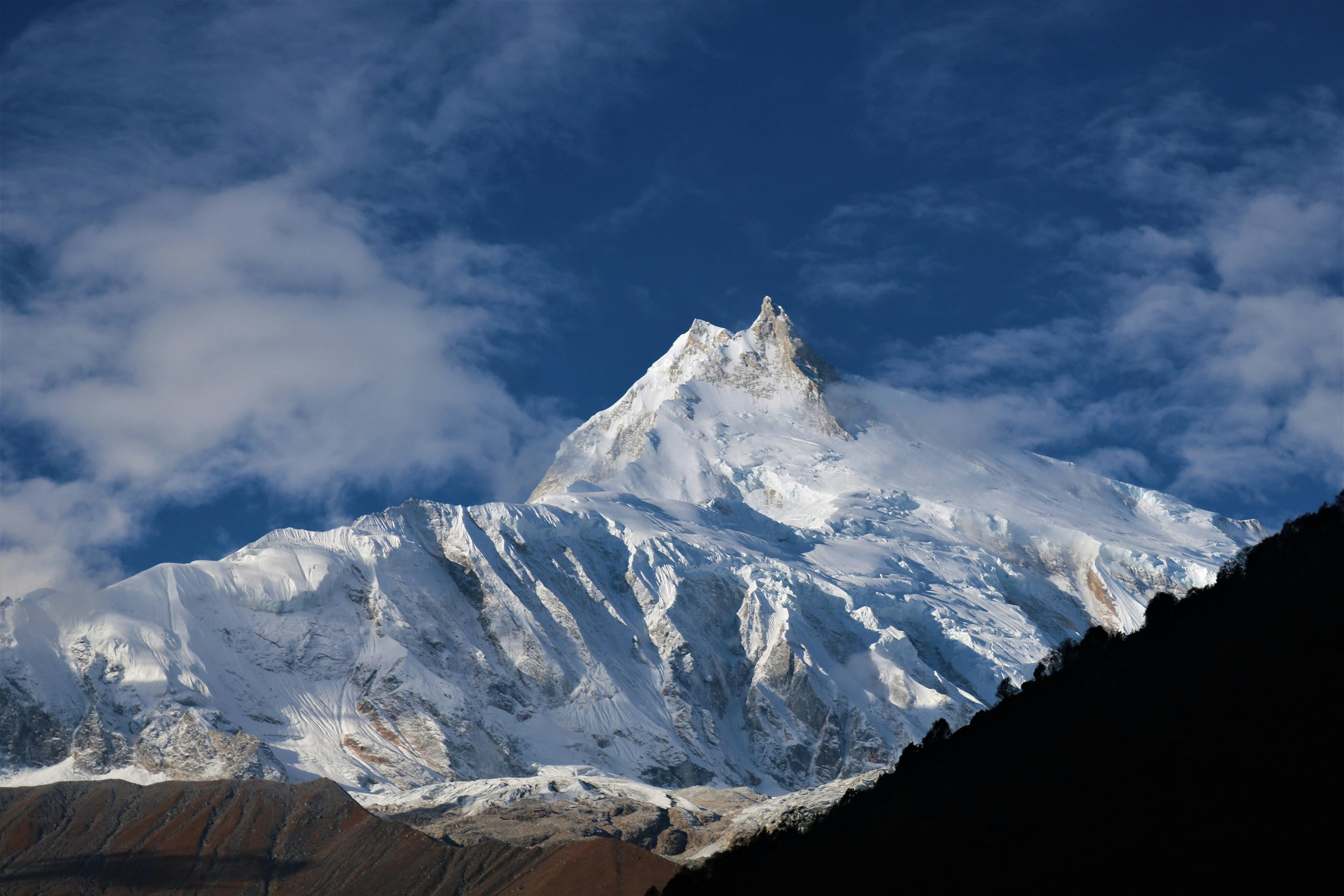
Manaslu Circuit Trek: overview
- Duration
- 12–18 days (typically 14)
- Difficulty
- Challenging
- Max altitude
- 5,106 m · Larkya La
- Start / finish
- Machha Khola (jeep from Pokhara via Gorkha and Arughat) → Dharapani / Besisahar, then Pokhara
- Best months
- Mar, Apr, Oct, Nov
- Sleep in
- Teahouses in every overnight village; rooms are basic twin rooms with shared toilets, and Dharamsala (Larkya Phedi) has a small number of rooms plus dorms or tents in peak season.
- Guide
- Licensed guide required
- Permits
- Manaslu Restricted Area Permit (RAP), Manaslu Conservation Area Permit (MCAP), Annapurna Conservation Area Permit (ACAP), TIMS card
The Manaslu Circuit follows the Budhi Gandaki river from about 900 m at Machha Khola, through a deep subtropical gorge, into Tibetan-Buddhist Nubri villages beneath Manaslu (8,163 m), then crosses the Larkya La (5,106 m) and drops into the Marsyangdi valley, where it meets the Annapurna Circuit at Dharapani. The standard itinerary is 14 days from Pokhara, including two acclimatisation days, at Samagaun and Samdo.
It sees far fewer trekkers than the Annapurna Circuit or Everest, because it is a restricted area: you need a special permit, a licensed guide and at least one other trekker. Lodges are simpler and the trail is rougher. The pass day is long, 8–10 hours from Dharamsala, and it starts in the dark. In return you get empty trails, mani walls and gompas in every village, and some of the closest views of an 8,000 m peak on any teahouse trek.
From Pokhara the approach is by jeep via Gorkha and Arughat to Machha Khola. On the far side, shared jeeps from Dharapani reach Besisahar in 4–5 hours, and Besisahar is another 4–5 hours from Pokhara, so it is a natural trek to start and finish in Pokhara. Mantra Mountain is based in Pokhara and runs this trek.
Highlights
- Crossing the Larkya La (5,106 m), with Himlung Himal, Cheo Himal and Kang Guru filling the view on the descent to Bimthang
- Close views of Manaslu (8,163 m) from Lho and Samagaun, one of the nearest looks at an 8,000 m peak from a teahouse
- The Budhi Gandaki gorge: long suspension bridges, waterfalls and stone staircases cut into cliffs between Machha Khola and Deng
- Nubri villages with Tibetan-Buddhist culture: Ribung Gompa at Lho, the monastery at Samagaun, mani walls stretching hundreds of metres
- An acclimatisation hike from Samagaun to Birendra Tal and Manaslu Base Camp (4,800 m) or Pungyen Gompa (about 4,000 m)
- Samdo, a high yak-herding village a day's walk from the Tibetan border
- Far quieter than the Annapurna Circuit or Everest, even in October
Day-by-day itinerary & route map
The standard 14-day itinerary from Pokhara. Tap any day, a marker on the map or a point on the altitude profile to follow the route. Walking times are for an average trekker at a steady pace, without long stops.
Route line and stops are approximate and drawn for planning — not for navigation. Terrain tiles © OpenTopoMap / OpenStreetMap contributors.
Show altitudes as a table
| Day | Route | Sleep | High point |
|---|---|---|---|
| 1 | Pokhara → Gorkha → Arughat → Machha Khola | 930 m | — |
| 2 | Machha Khola → Tatopani → Jagat | 1,340 m | — |
| 3 | Jagat → Philim → Deng | 1,860 m | — |
| 4 | Deng → Bihi Phedi → Ghap → Namrung | 2,630 m | — |
| 5 | Namrung → Lihi → Sho → Lho | 3,180 m | — |
| 6 | Lho → Shyala → Samagaun | 3,530 m | — |
| 7 | Acclimatisation day at Samagaun (Birendra Tal / Manaslu Base Camp or Pungyen Gompa) | 3,530 m | 4,800 m (Manaslu Base Camp) |
| 8 | Samagaun → Samdo | 3,860 m | — |
| 9 | Acclimatisation day at Samdo | 3,860 m | 4,600 m (Ridge above Samdo / trail toward Gya La) |
| 10 | Samdo → Dharamsala (Larkya Phedi) | 4,460 m | — |
| 11 | Dharamsala → Larkya La (5,106 m) → Bimthang | 3,720 m | 5,106 m (Larkya La) |
| 12 | Bimthang → Karche → Gho → Tilije | 2,300 m | — |
| 13 | Tilije → Thonje → Dharapani, jeep to Besisahar | 760 m | — |
| 14 | Besisahar → Pokhara | 822 m | — |
Day 1: Pokhara → Gorkha → Arughat → Machha Khola
- Sleep altitude
- ▲ 930 m
- Time
- ⏱ 8–9 h drive
Drive east on the Prithvi Highway to Abu Khaireni, climb to Gorkha, then descend to Arughat on the Budhi Gandaki. North of Arughat the dirt road gets rough, especially after rain, past Soti Khola to Machha Khola. Expect dust, river crossings and a slow final 2–3 hours.
Overnight: Teahouse, Machha Khola
Local tip: A private jeep from Pokhara is more comfortable and flexible than local buses with a change at Gorkha or Arughat. Sit on the right side for the river views.
Day 2: Machha Khola → Tatopani → Jagat
- Sleep altitude
- ▲ 1,340 m
- Time
- ⏱ 6–7 h walk
- Distance
- ≈ 22 km
The trail, sometimes on the new road cut, follows the Budhi Gandaki through Khorlabesi to the hot spring at Tatopani, then crosses to Dobhan and climbs over rocky sections to Jagat. It is hot and humid with lots of short ups and downs. At Jagat the restricted area permit and MCAP are checked.
Overnight: Teahouse, Jagat
Local tip: Jeeps sometimes run as far as Jagat in the dry season. Walk this day anyway if you can: it helps your fitness and acclimatisation, and the old trail skips most of the road dust.
Day 3: Jagat → Philim → Deng
- Sleep altitude
- ▲ 1,860 m
- Time
- ⏱ 6–7 h walk
- Distance
- ≈ 20 km
Climb to Philim (1,570 m), a large Gurung village with a school and fields of millet, then pass the junction where the Tsum Valley trail branches off to the right. The gorge narrows past Ekle Bhatti and Pewa, with bridges crossing and recrossing the river before Deng.
Overnight: Teahouse, Deng
Day 4: Deng → Bihi Phedi → Ghap → Namrung
- Sleep altitude
- ▲ 2,630 m
- Time
- ⏱ 6–7 h walk
- Distance
- ≈ 19 km
The valley swings west and you enter Nubri, with the first mani walls and chortens around Bihi Phedi and Ghap. From Ghap a long climb through pine and rhododendron forest gains about 500 m to Namrung, the first village with proper mountain views and some of the best lodges on the route.
Overnight: Teahouse, Namrung
Local tip: Namrung has a second checkpoint and usually the last reliable Wi-Fi until Samagaun, so send messages here.
Day 5: Namrung → Lihi → Sho → Lho
- Sleep altitude
- ▲ 3,180 m
- Time
- ⏱ 4–5 h walk
- Distance
- ≈ 10 km
A shorter day through the barley-farming villages of Banjam, Lihi and Sho, with Himal Chuli and Ngadi Chuli behind you and Manaslu ahead. Lho sits on a ridge under Ribung Gompa. Arriving by early afternoon gives you time for the monastery and the classic evening view of Manaslu's twin summits.
Overnight: Teahouse, Lho
Local tip: Walk up to Ribung Gompa above the village at sunrise, when Manaslu is almost always clearest.
Day 6: Lho → Shyala → Samagaun
- Sleep altitude
- ▲ 3,530 m
- Time
- ⏱ 3–4 h walk
- Distance
- ≈ 8 km
A gentle climb through forest to Shyala, where the valley opens into a wide bowl under Manaslu, Peak 29 and Himal Chuli, then an easy walk across fields to Samagaun. It is the largest village in Nubri, with a monastery, small shops and a health post. Rest in the afternoon.
Overnight: Teahouse, Samagaun
Day 7: Acclimatisation day at Samagaun (Birendra Tal / Manaslu Base Camp or Pungyen Gompa)
- Sleep altitude
- ▲ 3,530 m
- High point
- Max 4,800 m · Manaslu Base Camp
- Time
- ⏱ 7–8 h return (MBC) or 4–5 h (Pungyen Gompa)
- Type
- Acclimatisation day
Climb high and sleep low. The big option is Manaslu Base Camp (about 4,800 m), a steep 1,300 m climb past the milky-blue Birendra Tal glacier lake. It is a strong acclimatisation hike but a hard day. The gentler choice is Pungyen Gompa (about 4,000 m), a small monastery in a meadow facing the Manaslu Glacier.
Overnight: Teahouse, Samagaun
Local tip: If you have a headache or feel slow, take Birendra Tal (1 h each way) and stop there. Save your energy for the pass.
Day 8: Samagaun → Samdo
- Sleep altitude
- ▲ 3,860 m
- Time
- ⏱ 3–4 h walk
- Distance
- ≈ 8 km
An easy, gradual walk up the widening valley past juniper scrub and yak pastures, crossing the Budhi Gandaki on a wooden bridge before a short climb to Samdo. The village has around 40 houses and was settled by Tibetan refugees, and it is often windy and cold in the afternoon.
Overnight: Teahouse, Samdo
Day 9: Acclimatisation day at Samdo
- Sleep altitude
- ▲ 3,860 m
- High point
- Max 4,600 m · Ridge above Samdo / trail toward Gya La
- Time
- ⏱ 3–5 h return hike
- Type
- Acclimatisation day
Hike up the ridge behind the village or partway along the old trade route toward the Gya La on the Tibetan border, gaining 500–700 m before coming back to sleep. The views take in Samdo Peak, Manaslu's north side and the glaciers feeding the valley. You cannot cross into Tibet.
Overnight: Teahouse, Samdo
Local tip: This is the day to check your gear for the pass: headtorch batteries, a warm layer in reach and snacks for 8–10 hours.
Day 10: Samdo → Dharamsala (Larkya Phedi)
- Sleep altitude
- ▲ 4,460 m
- Time
- ⏱ 3–4 h walk
- Distance
- ≈ 6 km
Cross the Budhi Gandaki one last time and climb gradually past the Larke Bazaar ruins, an old trade market, to Dharamsala, a cluster of lodge buildings at the foot of the pass. It is a short day on purpose: you gain 600 m and need an early night before a 3–4 am start.
Overnight: Lodge / dorm, Dharamsala
Local tip: Rooms here are few and fill quickly in October; your guide should reserve ahead. Expect dorm beds and very cold nights.
Day 11: Dharamsala → Larkya La (5,106 m) → Bimthang
- Sleep altitude
- ▲ 3,720 m
- High point
- Max 5,106 m · Larkya La
- Time
- ⏱ 8–10 h walk
- Distance
- ≈ 16 km
Start by headtorch and climb for 3–5 hours over moraine and past small frozen lakes to the prayer-flagged pass. Some sources give 5,160 m, but 5,106 m is the surveyed height. On the far side a steep, often icy descent drops about 1,400 m, with Himlung Himal, Cheo Himal, Kang Guru and Annapurna II ahead, to the meadows of Bimthang.
Overnight: Teahouse, Bimthang
Local tip: The descent is the dangerous part, not the top. Carry microspikes in October–November and in spring, and don't linger at the pass if the wind picks up.
Day 12: Bimthang → Karche → Gho → Tilije
- Sleep altitude
- ▲ 2,300 m
- Time
- ⏱ 5–6 h walk
- Distance
- ≈ 14 km
Leave Bimthang with a look back at Manaslu's west face, cross the moraine of the Salpudanda Glacier and descend through rhododendron and pine forest along the Dudh Khola to Karche and Gho. Tilije is a large Gurung village with apple orchards. After two weeks above 3,000 m the thick air makes this day feel easy.
Overnight: Teahouse, Tilije
Day 13: Tilije → Thonje → Dharapani, jeep to Besisahar
- Sleep altitude
- ▲ 760 m
- Time
- ⏱ 1.5–2 h walk + 4–5 h jeep
- Distance
- ≈ 6 km
A short walk past Thonje to Dharapani (1,960 m) on the Annapurna Circuit road, where the ACAP permit is checked. Shared or private jeeps take the bumpy Marsyangdi valley road down through Tal, Chamje and Syange to Besisahar.
Overnight: Hotel, Besisahar
Local tip: If you start early you can go straight from Dharapani to Pokhara in one long day (8–9 h) by private jeep, which saves a night.
Day 14: Besisahar → Pokhara
- Sleep altitude
- ▲ 822 m
- Time
- ⏱ 4–5 h drive
Bus or jeep down to Dumre on the Prithvi Highway, then west to Pokhara, arriving in time for lunch by the lake. Keep a spare day in Pokhara before any flight home in case of road delays.
Overnight: Hotel, Pokhara
Best time to trek
- Jan: not ideal
- Feb: not ideal
- Mar: best
- Apr: best
- May: possible
- Jun: not ideal
- Jul: not ideal
- Aug: not ideal
- Sep: possible
- Oct: best
- Nov: best
- Dec: possible
Not sure which season suits you? Our month-by-month guide to trekking in Nepal covers weather, crowds and festivals.
Permits, fees & the guide rule
| Permit | Cost (foreigners) | Notes |
|---|---|---|
| Manaslu Restricted Area Permit (RAP) | Sep–Nov: USD 100 for the first 7 days, then USD 15/day. Dec–Aug: USD 75 for 7 days, then USD 10/day. | Issued only through a registered agency, for groups of 2+ with a licensed guide. It is charged for the days inside the restricted zone (from Jagat to the Larkya La); most itineraries need 8–10 days, so budget about USD 115–145 in autumn. |
| Manaslu Conservation Area Permit (MCAP) | NPR 3,000 (≈ USD 22) | Checked at Jagat. SAARC nationals pay less. |
| Annapurna Conservation Area Permit (ACAP) | NPR 3,000 (≈ USD 22); SAARC NPR 1,000 | Needed because the circuit exits through Bimthang and Dharapani, inside the Annapurna Conservation Area. |
| TIMS card | NPR 2,000 (≈ USD 15) | Issued through your trekking agency along with the other permits. |
Licensed guide required for foreign trekkers
Manaslu is a restricted area: foreigners need a Restricted Area Permit issued through a registered agency, a licensed guide for the whole trek and a group of at least two trekkers. Checkpoints at Jagat and Samagaun check all three.
Fees as of September 2026. Nepal changes permit rules and prices from time to time — confirm before you travel. Full details in our Nepal trekking permits guide.
Getting there
From Pokhara
Most trekkers based in Pokhara take a private jeep east on the Prithvi Highway to Abu Khaireni, up to Gorkha and down to Arughat, then on the rough road to Soti Khola and Machha Khola, 8–9 hours in total. The cheaper option is a bus to Gorkha (about 3 h), then a local bus or shared jeep via Arughat to Machha Khola, but this usually takes a full day or more. Your agency will need your passport a few days ahead to issue the restricted area permit, which is processed in Kathmandu, so organise it before you leave Pokhara.
From Kathmandu
Buses and shared jeeps leave the Gongabu / Machhapokhari area early in the morning for Arughat and Soti Khola or Machha Khola (7–9 h via Dhading Besi or via the Prithvi Highway and Gorkha). A private jeep is faster and lets you stop, and in the dry season jeeps can sometimes continue to Jagat or Philim, which saves a day.
The way back
From Dharapani, shared jeeps run down the Marsyangdi valley to Besisahar in 4–5 hours (roughly NPR 2,000–2,500 per seat), and buses cover Besisahar–Pokhara in 4–5 hours and Besisahar–Kathmandu in 6–7 hours. A private jeep can do Dharapani to Pokhara in one day. You can also walk on to Manang and cross the Thorong La instead; see the Annapurna Circuit guide.
How much does the Manaslu Circuit trek cost?
Move the sliders to estimate your own trip. Typical teahouse spend on this route is USD 35–55 per person per day for a room and three meals; a licensed guide costs USD 25–35 a day and a porter USD 18–25.
Estimated cost per person
USD 898
+ about USD 25 in tips for your staff
- Teahouse room & 3 meals × 14 daysUSD 490
- PermitsUSD 158
- Transport to & from trailheadUSD 40
- Licensed guide (shared by 2)USD 210
Do-it-yourself estimate for the Manaslu Circuit Trek, from typical 2026 teahouse prices. Excludes flights to Nepal, visa, insurance, gear, drinks, hot showers and charging fees.
- Permits add roughly USD 175–205 per person in autumn (RAP ~USD 115–145 plus MCAP, ACAP and TIMS), less in the Dec–Aug off-season.
- Transport is cheapest by bus and shared jeep (about USD 40–60 return). Splitting a private jeep Pokhara–Machha Khola and Dharapani–Pokhara between two costs more per person.
- The licensed guide is compulsory, so plan for the guide's full 14 days, shared between the group. A porter carries for two.
- Prices rise with altitude: dal bhat costs roughly twice as much in Samdo as in Machha Khola. There is nowhere to get cash on the trail.
- A realistic total for two trekkers sharing a guide is about USD 1,100–1,700 each for 14 days, before tips (about 10–15% of guide and porter wages) and gear.
Important things to know
Altitude & acclimatisation
You sleep above 3,500 m from day 6 and at 4,460 m at Dharamsala before a 5,106 m pass, so the two acclimatisation days at Samagaun and Samdo matter. Do not cut them to save money. Learn the signs of AMS (headache, nausea, loss of appetite, poor sleep) and tell your guide early. If symptoms get worse, go down; from Samdo or Dharamsala that means walking back to Samagaun, not over the pass.
The Larkya La day
Plan for 8–10 hours, starting at 3–4 am, with about 650 m of ascent and 1,400 m of descent. After fresh snow the pass can close for a day or more, especially from late November. There is no lodge between Dharamsala and Bimthang, so carry water, snacks and warm layers. If the pass is closed or someone in the group is unwell, the only other way out is back down the Budhi Gandaki.
Trail conditions & roads
A road is being cut up the Budhi Gandaki. In the dry season jeeps reach Jagat and sometimes Philim, and sections of the lower trail are now dusty road, although the old footpath often runs on the other bank. Landslides on the Machha Khola–Jagat section are common after the monsoon, so the first days can involve detours. On the far side, the jeep road runs up from Dharapani toward Tilije.
Charging, Wi-Fi & mobile network
NTC and Ncell have patchy coverage in the lower valley and at a few points up to Namrung; above that, NTC signal is intermittent in Samagaun and nothing reliable beyond. Several lodges in Namrung and Samagaun sell Wi-Fi, often slow and sometimes satellite-based. Charging costs NPR 200–500 per device at higher lodges and is limited at Dharamsala, so carry a 20,000 mAh power bank.
Money & ATMs
The last reliable ATMs are in Gorkha and Arughat on the way in; there are none on the circuit until Besisahar. Carry all the cash you need in Nepali rupees, around NPR 5,000–7,000 per person per day plus a buffer, in small notes. Cards are not accepted in lodges.
Water & food
Lodges serve dal bhat, noodles, fried rice, potatoes and Tibetan bread, and the menu shrinks as you climb. Filter or purify tap water (a filter bottle or chlorine or iodine tablets); boiled water is sold at most lodges. Avoid meat above Namrung, where it has usually been carried in unrefrigerated for days.
Weather & hazards
October–November brings the most stable skies, with nights below −10 °C at Dharamsala. March–April is warmer at low altitude and colder than you might expect on the pass. Monsoon (June–August) brings leeches, landslides and cloud, and from December to February snow can close the Larkya La for days. Watch for rockfall and mule trains on narrow gorge sections: always stand on the mountain side.
Rescue & insurance
Health posts exist at Samagaun and a few lower villages, but serious illness means a helicopter from Samagaun, Samdo or Bimthang, typically USD 3,000–6,000+. Your insurance must explicitly cover trekking to 5,200 m and helicopter evacuation. Carry the policy number and emergency phone number with you and give a copy to your guide.
Responsible trekking
Walk clockwise around mani walls and chortens, and ask before photographing people or monastery interiors. Refill bottles rather than buying plastic, and carry your batteries and wrappers out, because there is no waste collection above Jagat. Fair treatment of porters matters here, with loads over a 5,106 m pass: check that they have proper boots, warm clothing and insurance.
Tips for solo trekkers
- You cannot trek Manaslu alone. The permit requires at least two foreigners plus a licensed guide, so solo travellers join a small group; many Pokhara and Kathmandu agencies pair people up for the same start date.
- Joining someone only for the permit and then splitting up on the trail is not allowed. Checkpoints at Jagat, Namrung and Samagaun check the group, and your guide can be fined.
- October is the busiest month and the easiest time to find a partner and share lodges with other groups. From mid-December to February you may be the only group in Samdo.
- Women travelling alone generally find the trail safe and the Nubri communities welcoming. Choose an agency that can assign a female guide if you prefer, and share a room with your trek partner at Dharamsala, where space is tight.
- Agree before you start what happens if someone in your pair is sick at Samdo or Dharamsala, since the group has to stay together.
- Carry a Garmin inReach or similar satellite messenger if you want contact above Samagaun; mobile coverage is unreliable.
- Avoid the monsoon (late June to August) if you're inexperienced: landslides on the lower gorge are frequent and the views are mostly lost.
- Keep your own copy of your passport, permits and insurance details, even though the guide carries the originals.
More in our complete guide to solo trekking in Nepal.
What to pack for this trek
- Microspikes for the icy descent from the Larkya La (Oct–Apr)
- A −15 °C sleeping bag or a liner for lodge blankets, since Dharamsala is very cold
- A strong headtorch and spare batteries for the 3–4 am pass start
- A 20,000 mAh power bank; charging is limited and costly above Namrung
- Enough cash in small NPR notes for the whole trek
- A water filter or purification tablets
- Gaiters for snow or mud, and trekking poles for the long descents
- Diamox (after discussing it with your doctor) and a basic first-aid kit with blister care
The basics are the same for every Nepal trek — see our interactive packing checklist.
Route options & variations
Manaslu Circuit with Tsum Valley (20–22 days)
From the junction near Philim, turn right into the Tsum Valley, a Buddhist valley with nunneries at Rachen Gompa and Mu Gompa (about 3,700 m). Allow 6–8 extra days. You need the Tsum Valley Restricted Area Permit as well (Sep–Nov USD 40/week, Dec–Aug USD 30/week). The Tsum days also make a good gradual acclimatisation before the pass.
Short Manaslu (12 days)
Drive to Jagat or Philim if the road is open, drop the Lho night by walking Namrung to Samagaun in one day, and take a private jeep from Dharapani straight to Pokhara. This works only for fit trekkers, and it is the acclimatisation schedule that suffers, so keep at least one rest day at Samagaun.
Manaslu plus the Annapurna Circuit (20+ days)
Instead of taking a jeep from Dharapani, walk up the Marsyangdi to Chame and Manang and cross the Thorong La (5,416 m) to Muktinath and Jomsom. You arrive already acclimatised, and you can fly or drive from Jomsom back to Pokhara. You will need ACAP (which you already have) and more days on your guide.
Our recommendation
Book the Manaslu Circuit Trek with Mantra Mountain
We are a local operator based in Pokhara — the gateway to most of the treks in this guide. Booking with us means a government-licensed guide, permits and TIMS arranged before you arrive, transport from your Pokhara hotel to the trailhead, and a team on the phone if plans change on the trail. Foreign trekkers must trek this route with a licensed guide anyway, so it pays to choose one you trust.
- Licensed, English-speaking local guides
- Permits & TIMS handled for you
- Solo travellers welcome
- Itineraries adjusted to your pace and dates
Manaslu Circuit FAQ
How difficult is the Manaslu Circuit trek?
It is a challenging trek, harder than the Annapurna Circuit, mainly because of the long Larkya La day (8–10 hours at up to 5,106 m) and the rougher trail and simpler lodges. You don't need technical skills, but you should be fit enough to walk 6–7 hours on consecutive days with big ascents. Previous trekking at altitude is a real advantage.
Can I do the Manaslu Circuit without a guide?
No. Manaslu is a restricted area and the permit is issued only through a registered agency, for a minimum of two trekkers with a licensed guide. Solo travellers can join a group arranged by an agency.
How much does the Manaslu Circuit trek cost?
In autumn, permits cost roughly USD 175–205 per person (the restricted area permit plus MCAP, ACAP and TIMS). Add USD 35–55 a day for lodges and food, USD 25–35 a day for the guide (shared) and USD 40–150 for transport. Two people sharing a guide should budget about USD 1,100–1,700 each for 14 days, plus tips.
What is the best time for the Manaslu Circuit?
Mid-October to mid-November has the clearest skies and the most reliable pass conditions, and March to April is the second-best window. September can still be wet on the lower trail, and from December to February snow often closes the Larkya La.
How many days do you need for the Manaslu Circuit?
Plan 14 days from Pokhara, including two acclimatisation days and the drives in and out. Fit trekkers sometimes do it in 12 days, and adding the Tsum Valley makes it 20–22 days. Keep one spare day for landslides or a closed pass.
How high is the Larkya La pass, 5,106 m or 5,160 m?
Both figures appear on maps and in brochures. 5,106 m is the commonly surveyed height and the one we use, but either way it is the high point of the circuit and the altitude your insurance must cover.
Is there Wi-Fi and mobile signal on the Manaslu Circuit?
Mobile signal (NTC and Ncell) is patchy in the lower valley and disappears above Samagaun. Lodges in Namrung and Samagaun sell Wi-Fi, often slow, and Samdo and Dharamsala should be treated as offline. A satellite messenger is the only reliable way to stay in contact.
Can I start the Manaslu trek from Pokhara?
Yes. A jeep from Pokhara via Gorkha and Arughat reaches Machha Khola in 8–9 hours, and the circuit ends at Dharapani, 4–5 hours from Besisahar and another 4–5 hours from Pokhara. Pokhara is a convenient base, and the permits are arranged through your agency before you go.
Is the Manaslu Circuit good for beginners?
It is not ideal as a first trek. Remoteness, a 5,106 m pass and a compulsory group all make it harder to turn around or adjust plans. Most people build up with Poon Hill, Mardi Himal or Annapurna Base Camp first, although a fit beginner with a good guide and the full 14-day itinerary can manage it.
Still have questions? Browse 80+ answers about trekking in Nepal.
Ask us about the Manaslu Circuit trek
Tell us your dates, group size and fitness — our Pokhara team replies by email with honest advice, even if you decide to trek with someone else.