
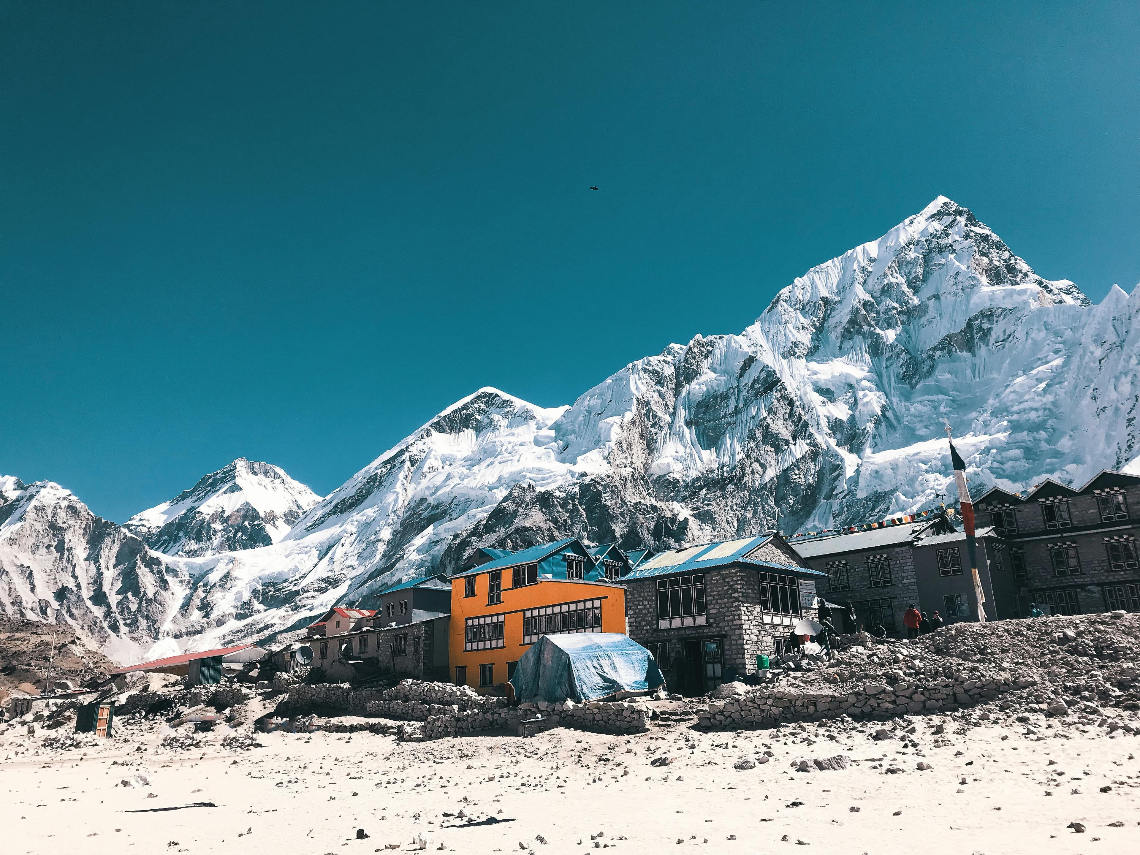
Everest Base Camp Trek: overview
- Duration
- 11–16 days (typically 12)
- Difficulty
- Challenging
- Max altitude
- 5,545 m · Kala Patthar
- Start / finish
- Lukla (flight from Kathmandu or Ramechhap) → Lukla, then flight to Kathmandu
- Best months
- Mar, Apr, May, Oct, Nov
- Sleep in
- Well-equipped teahouses all the way; many in Lukla, Namche and Dingboche have attached bathrooms and hot showers. Lobuche and Gorak Shep are basic, crowded and cold.
- Guide
- Guide recommended
- Permits
- Sagarmatha National Park entry, Khumbu Pasang Lhamu Rural Municipality entry
The Everest Base Camp trek starts with a 35-minute flight to Lukla (2,860 m) and follows the Dudh Koshi and Khumbu valleys through Namche Bazaar, Tengboche and Dingboche to Gorak Shep (5,164 m). From there you walk to Everest Base Camp (5,364 m) at the foot of the Khumbu Icefall and climb Kala Patthar (5,545 m), the viewpoint for Everest's summit. The standard itinerary is 12 days Kathmandu to Kathmandu, including acclimatisation days at Namche and Dingboche.
The trail itself is not technical and the lodges are the most comfortable of any high trek in Nepal. What makes it hard is the altitude: you spend four nights above 4,400 m and the air at Gorak Shep has about half the oxygen of sea level. Most problems come from climbing too fast, so the two rest days are not optional.
From Pokhara, you first need to get to Kathmandu by bus or flight, and in peak season many Lukla flights leave from Ramechhap (Manthali), a 4–5 hour drive from Kathmandu. Build at least one buffer day into your plans, because Lukla flights are often delayed by cloud. Mantra Mountain is based in Pokhara and runs this trek.
Highlights
- Sunrise from Kala Patthar (5,545 m), the classic view of Everest's summit, Nuptse and Changtse
- Standing at Everest Base Camp (5,364 m) beside the Khumbu Glacier and Icefall
- The flight into Lukla's short, sloping airstrip
- Namche Bazaar, the Sherpa trading town, and the Everest View Hotel viewpoint over Ama Dablam and Everest
- Tengboche Monastery, the largest in the Khumbu, with Ama Dablam behind it
- Ama Dablam, Lhotse, Island Peak and Pumori dominating the upper valley
- The climbers' memorials at Thukla Pass
Day-by-day itinerary & route map
The standard 12-day itinerary. Tap any day, a marker on the map or a point on the altitude profile to follow the route. Walking times are for an average trekker at a steady pace, without long stops.
Route line and stops are approximate and drawn for planning — not for navigation. Terrain tiles © OpenTopoMap / OpenStreetMap contributors.
Show altitudes as a table
| Day | Route | Sleep | High point |
|---|---|---|---|
| 1 | Fly Kathmandu → Lukla, trek to Phakding | 2,610 m | — |
| 2 | Phakding → Monjo → Namche Bazaar | 3,440 m | — |
| 3 | Acclimatisation day at Namche (Everest View Hotel) | 3,440 m | 3,880 m (Everest View Hotel) |
| 4 | Namche → Phunki Tenga → Tengboche | 3,860 m | — |
| 5 | Tengboche → Pangboche → Dingboche | 4,410 m | — |
| 6 | Acclimatisation day at Dingboche (Nangkartshang Peak) | 4,410 m | 5,083 m (Nangkartshang Peak) |
| 7 | Dingboche → Thukla → Lobuche | 4,940 m | — |
| 8 | Lobuche → Gorak Shep → Everest Base Camp → Gorak Shep | 5,164 m | 5,364 m (Everest Base Camp) |
| 9 | Kala Patthar sunrise → Lobuche → Pheriche | 4,240 m | 5,545 m (Kala Patthar) |
| 10 | Pheriche → Pangboche → Tengboche → Namche | 3,440 m | — |
| 11 | Namche → Monjo → Phakding → Lukla | 2,860 m | — |
| 12 | Fly Lukla → Kathmandu | 1,400 m | — |
Day 1: Fly Kathmandu → Lukla, trek to Phakding
- Sleep altitude
- ▲ 2,610 m
- Time
- ⏱ 35 min flight + 3–4 h walk
- Distance
- ≈ 8 km
An early flight lands on Lukla's 527 m uphill runway. After breakfast you walk mostly downhill past Chheplung to the Dudh Koshi river and Phakding. Losing 250 m on day one is good for acclimatisation, and the prayer wheels and mani stones start right away.
Overnight: Teahouse, Phakding
Local tip: Lukla flights are only possible in the morning and are cancelled when there is cloud. Keep your first-day walk bag light, as domestic flights enforce a 15 kg total allowance (about 10 kg hold + 5 kg hand).
Day 2: Phakding → Monjo → Namche Bazaar
- Sleep altitude
- ▲ 3,440 m
- Time
- ⏱ 6–7 h walk
- Distance
- ≈ 10 km
Follow the river north across several suspension bridges to Monjo, where your Sagarmatha National Park permit is checked. After Jorsale the trail crosses the high Hillary Bridge and climbs about 600 m steeply to Namche, with your first view of Everest from a bend halfway up, if it is clear.
Overnight: Teahouse, Namche Bazaar
Local tip: Take the long climb to Namche slowly and drink plenty; people often arrive with a headache because they hurry this section.
Day 3: Acclimatisation day at Namche (Everest View Hotel)
- Sleep altitude
- ▲ 3,440 m
- High point
- Max 3,880 m · Everest View Hotel
- Time
- ⏱ 3–4 h return hike
- Type
- Acclimatisation day
Climb to Syangboche and the Everest View Hotel (about 3,880 m) for a panorama of Everest, Lhotse and Ama Dablam, returning via Khumjung village and its Hillary school if you have energy. Back in Namche, visit the Sherpa museum and the national park visitor centre above town.
Overnight: Teahouse, Namche Bazaar
Day 4: Namche → Phunki Tenga → Tengboche
- Sleep altitude
- ▲ 3,860 m
- Time
- ⏱ 5–6 h walk
- Distance
- ≈ 10 km
A spectacular balcony trail contours round to Kyangjuma with Ama Dablam ahead, then drops to the river at Phunki Tenga (3,250 m) before a 600 m climb through rhododendron forest to Tengboche. The monastery holds prayers around 3 pm, and visitors can sit quietly at the back.
Overnight: Teahouse, Tengboche
Local tip: Tengboche has few lodges. If it is full, Deboche, 15 minutes further on, has more rooms and is quieter.
Day 5: Tengboche → Pangboche → Dingboche
- Sleep altitude
- ▲ 4,410 m
- Time
- ⏱ 5–6 h walk
- Distance
- ≈ 11 km
Walk through Deboche and Pangboche, the highest year-round Sherpa village with its old gompa, then above the tree line into the Imja valley. Dingboche is a spread of stone-walled potato fields and lodges below Ama Dablam and Island Peak. You gain about 550 m, so walk slowly.
Overnight: Teahouse, Dingboche
Day 6: Acclimatisation day at Dingboche (Nangkartshang Peak)
- Sleep altitude
- ▲ 4,410 m
- High point
- Max 5,083 m · Nangkartshang Peak
- Time
- ⏱ 4–5 h return hike
- Type
- Acclimatisation day
Climb the ridge behind the village toward Nangkartshang Peak (about 5,083 m). Even going halfway to 4,700–4,800 m helps you acclimatise, and the views of Makalu, Lhotse and the Imja valley are superb. Return for lunch and a quiet afternoon.
Overnight: Teahouse, Dingboche
Local tip: Turn back when you feel it, not when you reach the top; this day is about sleeping well afterwards.
Day 7: Dingboche → Thukla → Lobuche
- Sleep altitude
- ▲ 4,940 m
- Time
- ⏱ 5–6 h walk
- Distance
- ≈ 8 km
Walk above Pheriche across open pasture to Thukla (Dughla, 4,620 m), then climb steeply up the Khumbu Glacier's terminal moraine to the memorial cairns at Thukla Pass (about 4,830 m). From there it's a gentle walk up the moraine valley to Lobuche.
Overnight: Teahouse, Lobuche
Day 8: Lobuche → Gorak Shep → Everest Base Camp → Gorak Shep
- Sleep altitude
- ▲ 5,164 m
- High point
- Max 5,364 m · Everest Base Camp
- Time
- ⏱ 7–8 h walk
- Distance
- ≈ 15 km
A rocky moraine trail beside the Khumbu Glacier reaches Gorak Shep in 2–3 hours. After lunch, walk 2–2.5 hours each way over boulders and ice to Everest Base Camp, where in spring the expedition tents spread out below the Icefall. Everest's summit isn't visible from base camp itself.
Overnight: Teahouse, Gorak Shep
Local tip: Gorak Shep is the coldest, most crowded night of the trek. Book through your guide and expect water bottles to freeze in your room.
Day 9: Kala Patthar sunrise → Lobuche → Pheriche
- Sleep altitude
- ▲ 4,240 m
- High point
- Max 5,545 m · Kala Patthar
- Time
- ⏱ 2–3 h up/down + 5–6 h walk
- Distance
- ≈ 15 km
Leave around 4:30–5 am for the steep 1.5–2 hour climb up Kala Patthar, a dark ridge facing Everest, Nuptse, Changtse and Pumori. After breakfast in Gorak Shep, descend through Lobuche and Thukla to Pheriche. Dropping 1,300 m is the best cure for any altitude symptoms.
Overnight: Teahouse, Pheriche
Local tip: The Himalayan Rescue Association runs an aid post in Pheriche during the main seasons, a good place to get checked if you've had symptoms.
Day 10: Pheriche → Pangboche → Tengboche → Namche
- Sleep altitude
- ▲ 3,440 m
- Time
- ⏱ 6–7 h walk
- Distance
- ≈ 20 km
A long but mostly downhill day back through Pangboche and Tengboche. The climb from Phunki Tenga to Kyangjuma is the one real uphill. Namche's bakeries and hot showers feel luxurious after a week above 4,000 m.
Overnight: Teahouse, Namche Bazaar
Day 11: Namche → Monjo → Phakding → Lukla
- Sleep altitude
- ▲ 2,860 m
- Time
- ⏱ 6–7 h walk
- Distance
- ≈ 18 km
Descend steeply to the Hillary Bridge and retrace the Dudh Koshi valley. The final 200 m climb to Lukla catches many people out. Reconfirm your flight at the airline office or with your guide in the afternoon.
Overnight: Teahouse, Lukla
Day 12: Fly Lukla → Kathmandu
- Sleep altitude
- ▲ 1,400 m
- Time
- ⏱ 35 min flight
Morning flight to Kathmandu, or to Ramechhap followed by a 4–5 hour drive. Flights can be delayed for days in cloudy weather, so do not book onward international flights for the same or next day.
Overnight: Hotel, Kathmandu
Local tip: Keep 1–2 buffer days before your international flight. If you're stuck in Lukla, helicopter seats are sometimes shared among stranded trekkers, at a price.
Best time to trek
- Jan: not ideal
- Feb: possible
- Mar: best
- Apr: best
- May: best
- Jun: not ideal
- Jul: not ideal
- Aug: not ideal
- Sep: possible
- Oct: best
- Nov: best
- Dec: possible
Not sure which season suits you? Our month-by-month guide to trekking in Nepal covers weather, crowds and festivals.
Permits, fees & the guide rule
| Permit | Cost (foreigners) | Notes |
|---|---|---|
| Sagarmatha National Park entry | NPR 3,000 (≈ USD 22) | Bought at the park entrance in Monjo or at the Nepal Tourism Board in Kathmandu. |
| Khumbu Pasang Lhamu Rural Municipality entry | NPR 2,000 (≈ USD 15) | Collected in Lukla (or Monjo). No TIMS card is required in the Khumbu. |
A guide is recommended but not mandatory here
The Khumbu Pasang Lhamu Rural Municipality did not adopt the 2023 national guide rule, so independent trekking is still allowed in the Everest region. A guide or porter-guide is still recommended for altitude safety and flight rebooking; check current rules before you go.
Fees as of September 2026. Nepal changes permit rules and prices from time to time — confirm before you travel. Full details in our Nepal trekking permits guide.
Getting there
From Pokhara
There are no direct flights from Pokhara to Lukla. Take a tourist bus to Kathmandu (6–8 h, USD 10–25) or fly (25 min, USD 100–130) the day before, and sleep in Kathmandu. Lukla flights leave early in the morning, and in peak season often from Ramechhap (Manthali), which means a 2–3 am drive, so it is never realistic to travel from Pokhara on the same day.
From Kathmandu
Flights to Lukla cost about USD 220–250 one way and take 35 minutes. From about March to May and October to November, most scheduled flights are moved to Ramechhap (Manthali) airport, a 4–5 hour drive east, because of congestion at Kathmandu airport. Your agency normally arranges a shared jeep or tourist bus leaving at 1–3 am. Overland, you can drive to Salleri/Phaplu or Thamdanda and walk to Lukla in 1–3 days if you want to avoid flying.
The way back
Fly from Lukla to Kathmandu or Ramechhap, then continue to Pokhara by tourist bus or flight the next day. Weather delays of one to three days at Lukla are common in spring and in cloudy spells, so keep at least one buffer day before an international flight, ideally two.
How much does the Everest Base Camp trek cost?
Move the sliders to estimate your own trip. Typical teahouse spend on this route is USD 35–65 per person per day for a room and three meals; a licensed guide costs USD 25–35 a day and a porter USD 18–25.
Estimated cost per person
USD 1,096
+ about USD 22 in tips for your staff
- Teahouse room & 3 meals × 12 daysUSD 420
- PermitsUSD 36
- Transport to & from trailheadUSD 460
- Licensed guide (shared by 2)USD 180
Do-it-yourself estimate for the Everest Base Camp Trek, from typical 2026 teahouse prices. Excludes flights to Nepal, visa, insurance, gear, drinks, hot showers and charging fees.
- Transport shown is Kathmandu–Lukla return (about USD 440–500) plus Pokhara–Kathmandu return by bus or flight. From Kathmandu alone it's about USD 440–500.
- Permits are about USD 37 per person in total (Sagarmatha NP + Khumbu municipality); no TIMS is required.
- Hot showers (NPR 500–700), charging (NPR 300–600 per device) and Wi-Fi cost extra, and all get more expensive above Namche.
- A realistic total for 12 days is about USD 950–1,350 without a guide, or USD 1,300–1,900 per person for two sharing a guide and porter, plus tips.
- Budget for 1–2 extra nights in Kathmandu or Lukla in case flights are delayed.
Important things to know
Altitude & acclimatisation
From Dingboche you gain 1,100 m in three days to Gorak Shep, where the air has about half the oxygen of sea level, so keep the rest days at Namche and Dingboche. Headache, nausea, loss of appetite and unusual tiredness are early AMS symptoms; confusion, stumbling or breathlessness at rest mean go down immediately. Every season people are evacuated from Lobuche and Gorak Shep after skipping acclimatisation days.
Lukla flights
Flights operate only in visual conditions, usually in the first half of the morning, and morning cloud or afternoon wind stops them. Delays of several days happen, especially in spring and at the edges of the monsoon. Weight limits are strict (about 15 kg total), and extra baggage is charged per kilo. Keep your flight ticket and passport on you.
Charging, Wi-Fi & mobile network
NTC and Ncell have good 4G in Lukla and Namche and patchy coverage higher up; NTC often works in Gorak Shep. Most lodges sell Wi-Fi through Everest Link, and prepaid data cards bought in lodges work across the valley. Charging is solar or hydro and is charged per device above Namche, so bring a power bank and keep it warm at night.
Money & ATMs
There are ATMs in Lukla and Namche, but they often run out of cash or reject foreign cards and charge high fees. Carry enough Nepali rupees from Kathmandu for the whole trek. Some Namche shops and lodges accept cards with a 3–5% surcharge; above Namche it is cash only.
Water & food
Food is varied up to Namche (bakeries, pizza, espresso) and simplifies higher up: dal bhat, noodle soups, fried rice, potatoes. Purify all water. Refill stations run by the Sagarmatha Pollution Control Committee along the trail sell treated water cheaply and reduce plastic waste. Avoid meat above Namche; animals are not slaughtered in the Khumbu, so meat is carried in.
Weather & hazards
October–November has the clearest skies, with night temperatures of −10 to −15 °C at Gorak Shep. April–May is warmer, with more afternoon cloud and expedition tents at base camp. December–February is quiet, clear and very cold. Yaks and porters have right of way on the trail: always step to the uphill side. The dry, cold air causes the 'Khumbu cough', so a buff over your mouth helps.
Rescue & insurance
Helicopter rescue is widely available in the Khumbu but costs USD 3,000–6,000+, and insurers increasingly scrutinise claims. Your policy must cover trekking to 5,600 m and helicopter evacuation. Clinics operate in Lukla, Namche (Khunde Hospital nearby) and seasonally in Pheriche and Dingboche.
Responsible trekking
The Khumbu has a single-use plastic ban in parts of the municipality, so carry a refillable bottle. Pack out batteries, and walk clockwise around mani walls and chortens. Tip guides and porters directly and fairly, and choose an agency that equips and insures its porters for the cold at Gorak Shep.
Tips for solo trekkers
- You can legally trek to Everest Base Camp without a guide: the Khumbu local government did not adopt the 2023 guide rule. Check current rules before you travel, as this may change.
- The trail is busy from October to November and March to May, so solo trekkers are rarely alone. Lodge dining rooms in Namche, Dingboche and Lobuche are the easiest places to find walking partners.
- If you walk independently, tell your lodge each morning where you are going, and don't walk the Lobuche–Gorak Shep–EBC section alone in poor visibility.
- A porter-guide (USD 22–30/day) is good value for solo trekkers: someone to carry 10–15 kg, spot altitude symptoms and handle flight rebooking in Lukla.
- Women trekking solo find the Khumbu one of the safest trekking regions in Nepal. Stick to reputable lodges, and choose a guide through a registered agency, not someone met at the airport.
- Avoid late June to August. Flights are unreliable, the views are mostly hidden, and the trail is muddy and leech-prone below Namche.
- Never sleep higher than your body is ready for to keep up with a new friend's schedule; acclimatisation is individual.
- Walk with a group on Kala Patthar in the dark, and bring a headtorch and emergency layer.
More in our complete guide to solo trekking in Nepal.
What to pack for this trek
- A −15 °C or warmer-rated sleeping bag for Lobuche and Gorak Shep
- A down jacket, insulated gloves, a warm hat and a buff for the dry, dusty air
- Microspikes in winter and after late-season snow
- A 20,000 mAh power bank, kept warm in your sleeping bag at night
- Throat lozenges and lip balm with SPF for the Khumbu cough and sun
- Cash in small NPR notes for the whole trek
- A water filter or purification tablets and an insulated bottle cover
- Sunglasses with UV protection (category 3–4), since glare off the glacier is intense
The basics are the same for every Nepal trek — see our interactive packing checklist.
Route options & variations
EBC via Gokyo and the Cho La (15–17 days)
Go up the Gokyo valley first (see the Gokyo Lakes guide), climb Gokyo Ri, then cross the Cho La (5,420 m) to Dzongla and Lobuche to reach base camp. The loop avoids retracing your steps, but the glacier crossing on the Cho La is serious in snow, so a guide and microspikes are strongly recommended.
Everest Three Passes (18–20 days)
The full loop crosses the Kongma La (5,535 m), the Cho La (5,420 m) and the Renjo La (5,360 m), taking in Chhukung, EBC, Kala Patthar and Gokyo. It is only for fit, altitude-experienced trekkers. The acclimatisation it gives makes the EBC section easier.
No-Lukla-flight approach (16–20 days)
Drive from Kathmandu to Salleri/Phaplu or Thamdanda (10–12 h) and walk 1–3 days to join the main trail at Surke or Lukla, or follow the classic Jiri route. This avoids flight delays in both directions and acclimatises you gradually, at the cost of more days.
Our recommendation
Book the Everest Base Camp Trek with Mantra Mountain
We are a local operator based in Pokhara — the gateway to most of the treks in this guide. Booking with us means a government-licensed guide, permits and TIMS arranged before you arrive, transport from your Pokhara hotel to the trailhead, and a team on the phone if plans change on the trail.
- Licensed, English-speaking local guides
- Permits & TIMS handled for you
- Solo travellers welcome
- Itineraries adjusted to your pace and dates
Everest Base Camp FAQ
How difficult is the Everest Base Camp trek?
It is a challenging but non-technical trek: 5–7 hours of walking a day on good trails, with the difficulty coming from the altitude. Anyone with reasonable fitness who acclimatises properly can usually reach base camp; the hardest days are Lobuche to Gorak Shep and the dawn climb up Kala Patthar.
Can I do the Everest Base Camp trek without a guide?
Yes. The Khumbu local government did not adopt Nepal's 2023 compulsory-guide rule, so independent trekking is still allowed in the Everest region; check the current rules before you go. A guide or porter-guide is still recommended, especially for altitude safety and for handling flight delays.
How much does the Everest Base Camp trek cost?
Budget about USD 440–500 for return Lukla flights, USD 37 for permits and USD 35–65 a day for lodges and food. A 12-day trip costs roughly USD 950–1,350 independently, or USD 1,300–1,900 per person with a shared guide and porter, before tips and gear.
What is the best time for the Everest Base Camp trek?
Mid-October to November gives the clearest mountain views, and April to May brings warmer weather and the expedition season at base camp. December to February is quiet and clear but very cold, while June to August is cloudy and flights are unreliable.
How many days do you need for Everest Base Camp?
The standard itinerary is 12 days Kathmandu to Kathmandu, including two acclimatisation days. Add 1–2 buffer days for Lukla flight delays, and 1–2 more to get to and from Pokhara if you are based there.
Is there Wi-Fi on the Everest Base Camp trek?
Yes. Most lodges sell Wi-Fi through Everest Link, including at Gorak Shep, and NTC or Ncell 4G works in Lukla and Namche and in patches higher up. Expect to pay for Wi-Fi and charging above Namche.
Do I need a permit for Everest Base Camp?
You need the Sagarmatha National Park entry permit (NPR 3,000) and the Khumbu Pasang Lhamu Rural Municipality fee (NPR 2,000). Both are bought on the trail at Lukla and Monjo or in Kathmandu. No TIMS card is required in the Khumbu.
Can I trek to Everest Base Camp from Pokhara?
Not directly: the Everest region is in eastern Nepal. From Pokhara, take a bus or flight to Kathmandu the day before your Lukla flight, and expect a 1–3 am drive to Ramechhap in peak season. Allow 14–16 days in total from Pokhara, including buffer days.
Is Everest Base Camp good for beginners?
Yes, if you are reasonably fit and follow a proper acclimatisation schedule. Plenty of first-time trekkers do it every season. Training with long hill walks beforehand and keeping the rest days at Namche and Dingboche make the biggest difference.
Still have questions? Browse 80+ answers about trekking in Nepal.
Ask us about the Everest Base Camp trek
Tell us your dates, group size and fitness — our Pokhara team replies by email with honest advice, even if you decide to trek with someone else.