
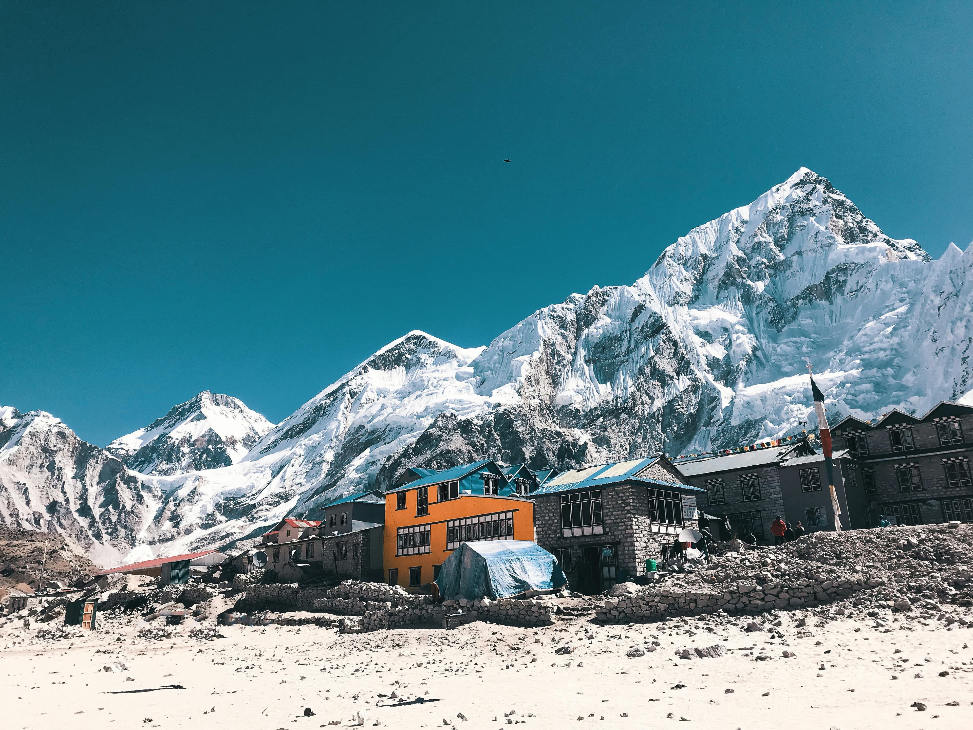
Gokyo Lakes & Gokyo Ri Trek: overview
- Duration
- 10–14 days (typically 11)
- Difficulty
- Challenging
- Max altitude
- 5,357 m · Gokyo Ri
- Start / finish
- Lukla (flight from Kathmandu or Ramechhap) → Lukla, then flight to Kathmandu
- Best months
- Mar, Apr, May, Oct, Nov
- Sleep in
- Comfortable teahouses in Namche, Dole, Machhermo and Gokyo; Gokyo's lodges sit on the lakeshore and several have heated dining rooms and attached bathrooms.
- Guide
- Guide recommended
- Permits
- Sagarmatha National Park entry, Khumbu Pasang Lhamu Rural Municipality entry
The Gokyo trek leaves the main Everest trail above Namche and climbs the Dudh Koshi valley through Dole and Machhermo to Gokyo (4,790 m). The village sits on the shore of the third of six turquoise glacier lakes beside the Ngozumpa Glacier, the longest in Nepal. From Gokyo Ri (5,357 m), a 2–3 hour climb above the village, you see Everest, Lhotse, Makalu and Cho Oyu, four of the world's six highest mountains, in one sweep.
It is a similar length to Everest Base Camp (11 days Kathmandu to Kathmandu) with a slightly lower sleeping altitude and far fewer trekkers. The trail gains height steadily, so the itinerary has a rest day at Namche and short days above it. Many people rate the Gokyo Ri view above Kala Patthar's.
For a longer trip, the Cho La (5,420 m) links Gokyo to Lobuche and Everest Base Camp in a 15–17 day loop. If you'd like help planning it, send us a question from this page.
Highlights
- Gokyo Ri (5,357 m) at sunrise: Everest, Lhotse, Makalu and Cho Oyu in one panorama
- Six turquoise Gokyo lakes, a protected Ramsar wetland, with a walk to the Fourth and Fifth Lakes
- The Ngozumpa Glacier, Nepal's longest, running alongside Gokyo village
- Far fewer trekkers than the main Everest Base Camp trail
- Namche Bazaar and the Everest View Hotel acclimatisation hike
- Cho Oyu (8,188 m) filling the head of the valley from Machhermo onwards
Day-by-day itinerary & route map
The standard 11-day itinerary. Tap any day, a marker on the map or a point on the altitude profile to follow the route. Walking times are for an average trekker at a steady pace, without long stops.
Route line and stops are approximate and drawn for planning — not for navigation. Terrain tiles © OpenTopoMap / OpenStreetMap contributors.
Show altitudes as a table
| Day | Route | Sleep | High point |
|---|---|---|---|
| 1 | Fly Kathmandu → Lukla, trek to Phakding | 2,610 m | — |
| 2 | Phakding → Monjo → Namche Bazaar | 3,440 m | — |
| 3 | Acclimatisation day at Namche | 3,440 m | 3,880 m (Everest View Hotel) |
| 4 | Namche → Mong La → Phortse Tenga → Dole | 4,040 m | — |
| 5 | Dole → Luza → Machhermo | 4,470 m | — |
| 6 | Machhermo → Pangka → Gokyo | 4,790 m | — |
| 7 | Gokyo Ri sunrise, optional Fourth & Fifth Lakes | 4,790 m | 5,357 m (Gokyo Ri) |
| 8 | Gokyo → Machhermo → Dole | 4,040 m | — |
| 9 | Dole → Phortse Tenga → Mong La → Namche | 3,440 m | — |
| 10 | Namche → Monjo → Phakding → Lukla | 2,860 m | — |
| 11 | Fly Lukla → Kathmandu | 1,400 m | — |
Day 1: Fly Kathmandu → Lukla, trek to Phakding
- Sleep altitude
- ▲ 2,610 m
- Time
- ⏱ 35 min flight + 3–4 h walk
- Distance
- ≈ 8 km
An early flight to Lukla (2,860 m), then a mostly downhill walk past Chheplung to the Dudh Koshi and Phakding. It is an easy first day that starts you acclimatising gently.
Overnight: Teahouse, Phakding
Local tip: In peak season your flight may leave from Ramechhap. Ask your agency the day before what time the jeep leaves Kathmandu.
Day 2: Phakding → Monjo → Namche Bazaar
- Sleep altitude
- ▲ 3,440 m
- Time
- ⏱ 6–7 h walk
- Distance
- ≈ 10 km
Follow the river north across suspension bridges to the park gate at Monjo, then cross the Hillary Bridge and climb about 600 m steeply to Namche. Walk slowly on the climb, which is where people most often overdo it.
Overnight: Teahouse, Namche Bazaar
Day 3: Acclimatisation day at Namche
- Sleep altitude
- ▲ 3,440 m
- High point
- Max 3,880 m · Everest View Hotel
- Time
- ⏱ 3–4 h return hike
- Type
- Acclimatisation day
Hike up to Syangboche and the Everest View Hotel for your first proper view of Everest and Ama Dablam, and loop back through Khumjung. Afternoon in Namche for any last supplies; prices rise sharply above here.
Overnight: Teahouse, Namche Bazaar
Day 4: Namche → Mong La → Phortse Tenga → Dole
- Sleep altitude
- ▲ 4,040 m
- Time
- ⏱ 5–6 h walk
- Distance
- ≈ 11 km
Follow the balcony trail toward Kyangjuma and fork left up to Mong La (3,973 m), a ridge-top chorten with a famous view of Ama Dablam. Then drop steeply to Phortse Tenga on the river and climb through rhododendron and birch forest to Dole.
Overnight: Teahouse, Dole
Local tip: The Mong La viewpoint has a couple of teahouses. Stop for tea while the view is clear, as it clouds over by late morning.
Day 5: Dole → Luza → Machhermo
- Sleep altitude
- ▲ 4,470 m
- Time
- ⏱ 3–4 h walk
- Distance
- ≈ 6 km
A short day climbing above the tree line on open slopes, with Cho Oyu ahead and Kangtega and Thamserku behind, past the summer settlements of Lhabarma and Luza. Machhermo has an HRA health post which often gives a free altitude talk at 3 pm in season.
Overnight: Teahouse, Machhermo
Local tip: Keep the day short on purpose and don't push on to Gokyo; you're gaining 430 m to sleep at 4,470 m.
Day 6: Machhermo → Pangka → Gokyo
- Sleep altitude
- ▲ 4,790 m
- Time
- ⏱ 4–5 h walk
- Distance
- ≈ 7 km
Walk up to a ridge with views up and down the valley, past Pangka, then climb a rocky path beside the Ngozumpa Glacier's moraine. You pass the First Lake (Longponga) and Second Lake before reaching Gokyo on the shore of the Third Lake (Dudh Pokhari).
Overnight: Teahouse, Gokyo
Day 7: Gokyo Ri sunrise, optional Fourth & Fifth Lakes
- Sleep altitude
- ▲ 4,790 m
- High point
- Max 5,357 m · Gokyo Ri
- Time
- ⏱ 3–4 h Gokyo Ri + optional 5–6 h lakes
- Type
- Acclimatisation day
Climb the steep zigzag path up Gokyo Ri, about 550 m in 2–3 hours from the lake, for sunrise over Everest, Lhotse, Makalu, Cho Oyu and the Ngozumpa Glacier. After breakfast, fit trekkers can walk up the valley to the Fourth Lake and Fifth Lake (about 5,000 m) for the Scoundrel's Viewpoint looking up at Cho Oyu.
Overnight: Teahouse, Gokyo
Local tip: Many people climb Gokyo Ri in the afternoon of day 6 when the light falls on Everest. If you do, use the morning of day 7 for the Fifth Lake instead.
Day 8: Gokyo → Machhermo → Dole
- Sleep altitude
- ▲ 4,040 m
- Time
- ⏱ 5–6 h walk
- Distance
- ≈ 13 km
Retrace the valley downhill, past the lakes and through Machhermo and Luza to Dole, losing 750 m. Walking back down the valley, you get the view of Kangtega and Thamserku ahead that was behind you on the way up.
Overnight: Teahouse, Dole
Day 9: Dole → Phortse Tenga → Mong La → Namche
- Sleep altitude
- ▲ 3,440 m
- Time
- ⏱ 5–6 h walk
- Distance
- ≈ 11 km
Descend through forest to Phortse Tenga, climb back up to Mong La (the day's main effort, about 300 m) and follow the balcony trail round to Namche for a hot shower and a bakery stop.
Overnight: Teahouse, Namche Bazaar
Day 10: Namche → Monjo → Phakding → Lukla
- Sleep altitude
- ▲ 2,860 m
- Time
- ⏱ 6–7 h walk
- Distance
- ≈ 18 km
A long descent to the Hillary Bridge, back along the Dudh Koshi and a final 200 m climb to Lukla. Reconfirm your flight in the afternoon.
Overnight: Teahouse, Lukla
Day 11: Fly Lukla → Kathmandu
- Sleep altitude
- ▲ 1,400 m
- Time
- ⏱ 35 min flight
Morning flight to Kathmandu, or to Ramechhap followed by a 4–5 hour drive. Cloud frequently delays Lukla flights, so keep at least one buffer day before international travel.
Overnight: Hotel, Kathmandu
Best time to trek
- Jan: not ideal
- Feb: not ideal
- Mar: best
- Apr: best
- May: best
- Jun: not ideal
- Jul: not ideal
- Aug: not ideal
- Sep: possible
- Oct: best
- Nov: best
- Dec: possible
Not sure which season suits you? Our month-by-month guide to trekking in Nepal covers weather, crowds and festivals.
Permits, fees & the guide rule
| Permit | Cost (foreigners) | Notes |
|---|---|---|
| Sagarmatha National Park entry | NPR 3,000 (≈ USD 22) | Bought at Monjo or in Kathmandu. |
| Khumbu Pasang Lhamu Rural Municipality entry | NPR 2,000 (≈ USD 15) | Collected at Lukla or Monjo. No TIMS card is required in the Khumbu. |
A guide is recommended but not mandatory here
Like the rest of the Khumbu, the Gokyo valley does not enforce the 2023 guide rule, so independent trekking is allowed. A guide is recommended, and strongly recommended if you plan to cross the Cho La or Renjo La.
Fees as of September 2026. Nepal changes permit rules and prices from time to time — confirm before you travel. Full details in our Nepal trekking permits guide.
Getting there
From Pokhara
Travel to Kathmandu the day before your Lukla flight, by tourist bus (6–8 h, USD 10–25) or a 25-minute flight (USD 100–130). There are no Pokhara–Lukla flights, and Lukla departures are early morning (from Ramechhap in peak season, with a 1–3 am drive), so a same-day connection isn't realistic.
From Kathmandu
Fly Kathmandu–Lukla (about USD 220–250 one way, 35 min). From roughly March to May and October to November, most flights use Ramechhap (Manthali), a 4–5 hour drive east of Kathmandu, and agencies run shared jeeps and buses in the early hours. The overland alternative is a jeep to Salleri/Phaplu or Thamdanda and a 1–3 day walk to Lukla.
The way back
Fly Lukla–Kathmandu or Ramechhap and continue to Pokhara the next day by bus or flight. Delays of one to three days are common, so keep at least one buffer day before an international flight.
How much does the Gokyo Lakes trek cost?
Move the sliders to estimate your own trip. Typical teahouse spend on this route is USD 35–65 per person per day for a room and three meals; a licensed guide costs USD 25–35 a day and a porter USD 18–25.
Estimated cost per person
USD 1,046
+ about USD 20 in tips for your staff
- Teahouse room & 3 meals × 11 daysUSD 385
- PermitsUSD 36
- Transport to & from trailheadUSD 460
- Licensed guide (shared by 2)USD 165
Do-it-yourself estimate for the Gokyo Lakes & Gokyo Ri Trek, from typical 2026 teahouse prices. Excludes flights to Nepal, visa, insurance, gear, drinks, hot showers and charging fees.
- Transport shown is Kathmandu–Lukla return (about USD 440–500) plus Pokhara–Kathmandu return; from Kathmandu alone it's about USD 440–500.
- Permits are about USD 37 per person in total; no TIMS is needed.
- Gokyo lodges charge extra for hot showers, charging and Wi-Fi, and prices at Gokyo are roughly double Namche's.
- A realistic total for 11 days is about USD 900–1,300 independently, or USD 1,250–1,800 per person with a guide and porter shared between two, plus tips.
Important things to know
Altitude & acclimatisation
You gain about 1,350 m from Namche to Gokyo in three days, keeping each day's sleeping gain under about 450 m. Do not skip the Namche rest day or combine Machhermo and Gokyo. If you have AMS symptoms, stay put or descend; Machhermo's HRA post in season is the place to get checked.
Lukla flights
Flights operate only in good visibility, usually in the early morning, and cloud can ground them for days. The baggage allowance is about 15 kg in total. Keep 1–2 buffer days at the end of the trip.
Charging, Wi-Fi & mobile network
NTC and Ncell 4G work in Lukla and Namche; above Namche the signal is patchy, but most lodges in Dole, Machhermo and Gokyo sell Wi-Fi through Everest Link data cards. Charging is paid per device and solar-limited in cloudy weather, so carry a power bank.
Money & ATMs
The last ATMs are in Namche and they're unreliable, so bring all the Nepali rupees you need from Kathmandu. Above Namche it is cash only, in small notes.
Water & food
Menus are simpler above Namche: dal bhat, noodle soup, potatoes, Tibetan bread and pasta. Purify all water, and use the treated-water refill stations where they exist rather than buying plastic bottles. Avoid meat above Namche.
Weather & hazards
Autumn gives crisp, clear mornings, with nights around −10 to −15 °C at Gokyo. Afternoon cloud often rises up the valley, so climb viewpoints early. The Gokyo Ri path and the lake edges can be icy in winter. Keep off frozen lakes: they are sacred and the ice is unreliable.
Rescue & insurance
Helicopters can land at Gokyo, Machhermo and Dole, and an evacuation typically costs USD 3,000–6,000+. Insurance must cover trekking to at least 5,400 m, or 5,500 m if you plan to cross the Cho La, plus helicopter rescue.
Tips for solo trekkers
- Independent trekking is allowed in the Gokyo valley, but it is quieter than the EBC trail. Walk with others, or take a porter-guide, if you're not experienced at altitude.
- Evening dining rooms at Namche, Machhermo and Gokyo are where solo trekkers group up; many people meet partners there for the Cho La or the Fifth Lake walk.
- Do not cross the Cho La or Renjo La alone. Route-finding on snow and the Cho La glacier is tricky, and people are injured every season.
- Tell your lodge where you are going when you climb Gokyo Ri or walk to the Fifth Lake, and set a turnaround time.
- Women trekkers usually find Gokyo safe and the lodges welcoming. Choose guides only through registered agencies.
- The Gokyo valley is at its best in November. Avoid July and August, when cloud hides the peaks and the Lukla flights are unreliable.
- Acclimatisation is individual: don't follow a faster group's schedule from Machhermo to Gokyo if you are not feeling right.
More in our complete guide to solo trekking in Nepal.
What to pack for this trek
- A −15 °C-rated sleeping bag for Gokyo nights
- A headtorch for the pre-dawn climb of Gokyo Ri
- Microspikes and gaiters if you're crossing the Cho La or trekking between December and March
- UV sunglasses (category 3–4); snow and lake glare are intense
- A 20,000 mAh power bank
- Cash in small NPR notes for the whole trek
- A water filter or purification tablets
The basics are the same for every Nepal trek — see our interactive packing checklist.
Route options & variations
Gokyo to Everest Base Camp via the Cho La (15–17 days)
From Gokyo cross the Ngozumpa Glacier to Thagnak (Dragnag, about 4,700 m), climb the Cho La (5,420 m) over a small glacier to Dzongla, and continue to Lobuche, Gorak Shep, EBC and Kala Patthar. It is the best way to see both valleys, but it is a serious pass: a guide and microspikes are strongly recommended, and it may be impassable after heavy snow.
Renjo La loop to Thame (13–14 days)
Instead of retracing your steps, cross the Renjo La (5,360 m) west of Gokyo to Lungden and descend the Bhote Koshi valley through Thame back to Namche. The views from the pass back over the Gokyo lakes and Everest are superb, and you'll see very few other trekkers.
Everest Three Passes (18–20 days)
Combine the Kongma La, Cho La and Renjo La with Gokyo, Everest Base Camp and Chhukung for the full Khumbu circuit. This is only for fit trekkers with previous altitude experience.
Our recommendation
Plan the Gokyo Lakes & Gokyo Ri Trek with a Pokhara team
We are a local operator based in Pokhara — the gateway to most of the treks in this guide. Booking with us means a government-licensed guide, permits and TIMS arranged before you arrive, transport from your Pokhara hotel to the trailhead, and a team on the phone if plans change on the trail.
- Licensed, English-speaking local guides
- Permits & TIMS handled for you
- Solo travellers welcome
- Itineraries adjusted to your pace and dates
Gokyo Lakes FAQ
Is the Gokyo Lakes trek better than Everest Base Camp?
They are different rather than better or worse. Gokyo is quieter and has the lakes and a view from Gokyo Ri that many people prefer to Kala Patthar, while EBC has base camp itself and the Khumbu Glacier. If you have 16–17 days, the Cho La lets you do both.
How difficult is the Gokyo Lakes trek?
It is challenging mainly because of altitude: you sleep at 4,790 m and climb to 5,357 m. Daily walks are 4–6 hours on good trails, and the only steep effort is the climb from Namche and up Gokyo Ri.
Can I do the Gokyo trek without a guide?
Yes, the Khumbu does not enforce the 2023 guide rule, so independent trekking is allowed; check current rules before you go. A guide is still recommended for altitude safety, and strongly recommended if you plan to cross the Cho La.
How many days is the Gokyo Lakes trek?
Eleven days Kathmandu to Kathmandu is standard, including a rest day at Namche and a full day at Gokyo. Add 1–2 buffer days for Lukla flights and 4–6 days if you want to continue to Everest Base Camp via the Cho La.
How much does the Gokyo trek cost?
Expect about USD 440–500 for Lukla flights, USD 37 for permits and USD 35–65 a day for lodges and food. The total is roughly USD 900–1,300 independently, or USD 1,250–1,800 per person with a shared guide and porter.
What is the best time to visit Gokyo Lakes?
October to November for clear skies and March to May for warmer days. In winter the lakes freeze and the views are sharp, but nights drop well below −15 °C and some lodges close.
Do I need a permit for the Gokyo trek?
Yes: the Sagarmatha National Park permit (NPR 3,000) and the Khumbu Pasang Lhamu Rural Municipality fee (NPR 2,000), the same as for Everest Base Camp. No TIMS card is needed.
Is there Wi-Fi at Gokyo?
Most Gokyo lodges sell Wi-Fi through Everest Link data cards, and it is usually usable though slow. Mobile signal is patchy above Namche.
Still have questions? Browse 80+ answers about trekking in Nepal.
Ask us about the Gokyo Lakes trek
Tell us your dates, group size and fitness — our Pokhara team replies by email with honest advice, even if you decide to trek with someone else.